You are here: Home > Network List > AK - Alaska Regional Network Stations List
> Station SAW Sawmill > Earthquake Result Viewer
SAW Sawmill - Earthquake Result Viewer
| Earthquake location: |
Iran-Iraq Border Region |
| Earthquake latitude/longitude: |
34.9/46.0 |
| Earthquake time(UTC): |
2017/11/12 (316) 18:18:17 GMT |
| Earthquake Depth: |
19 km |
| Earthquake Magnitude: |
7.3 Mww |
| Earthquake Catalog/Contributor: |
NEIC PDE/us |
|
| Network: |
AK Alaska Regional Network |
| Station: |
SAW Sawmill |
| Lat/Lon: |
61.81 N/148.33 W |
| Elevation: |
782 m |
|
| Distance: |
82.9 deg |
| Az: |
6.782 deg |
| Baz: |
348.208 deg |
| Ray Param: |
0.046528347 |
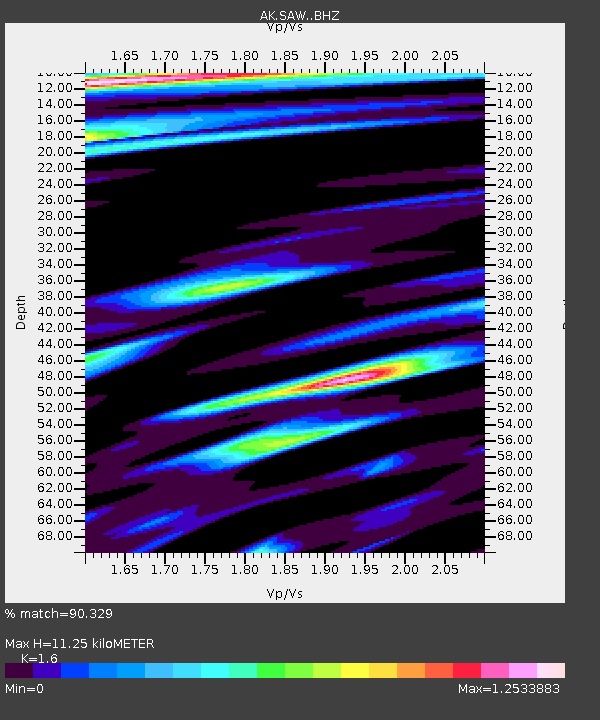
| Estimated Moho Depth: |
11.25 km |
| Estimated Crust Vp/Vs: |
1.60 |
| Assumed Crust Vp: |
6.566 km/s |
| Estimated Crust Vs: |
4.104 km/s |
| Estimated Crust Poisson's Ratio: |
0.18 |
|
| Radial Match: |
90.329 % |
| Radial Bump: |
400 |
| Transverse Match: |
84.589775 % |
| Transverse Bump: |
400 |
| SOD ConfigId: |
13570011 |
| Insert Time: |
2019-04-29 04:25:59.375 +0000 |
| GWidth: |
2.5 |
| Max Bumps: |
400 |
| Tol: |
0.001 |
|

Signal To Noise
| Channel | StoN | STA | LTA |
| AK:SAW: :BHZ:20171112T18:30:09.388022Z | 45.44963 | 1.6345288E-5 | 3.5963518E-7 |
| AK:SAW: :BHN:20171112T18:30:09.388022Z | 19.097067 | 6.571983E-6 | 3.441357E-7 |
| AK:SAW: :BHE:20171112T18:30:09.388022Z | 4.5134606 | 2.139163E-6 | 4.7395184E-7 |
| Arrivals |
| Ps | 1.1 SECOND |
| PpPs | 4.3 SECOND |
| PsPs/PpSs | 5.4 SECOND |


