You are here: Home > Network List > AK - Alaska Regional Network Stations List
> Station WAT6 Susitna Watana 6, AK, USA > Earthquake Result Viewer
WAT6 Susitna Watana 6, AK, USA - Earthquake Result Viewer
| Earthquake location: |
Iran-Iraq Border Region |
| Earthquake latitude/longitude: |
34.9/46.0 |
| Earthquake time(UTC): |
2017/11/12 (316) 18:18:17 GMT |
| Earthquake Depth: |
19 km |
| Earthquake Magnitude: |
7.3 Mww |
| Earthquake Catalog/Contributor: |
NEIC PDE/us |
|
| Network: |
AK Alaska Regional Network |
| Station: |
WAT6 Susitna Watana 6, AK, USA |
| Lat/Lon: |
62.58 N/147.74 W |
| Elevation: |
1681 m |
|
| Distance: |
82.2 deg |
| Az: |
6.352 deg |
| Baz: |
348.673 deg |
| Ray Param: |
0.047017675 |
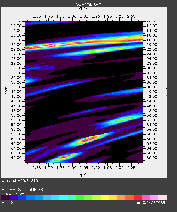
| Estimated Moho Depth: |
20.0 km |
| Estimated Crust Vp/Vs: |
1.72 |
| Assumed Crust Vp: |
6.566 km/s |
| Estimated Crust Vs: |
3.812 km/s |
| Estimated Crust Poisson's Ratio: |
0.25 |
|
| Radial Match: |
95.34315 % |
| Radial Bump: |
338 |
| Transverse Match: |
74.58092 % |
| Transverse Bump: |
400 |
| SOD ConfigId: |
13570011 |
| Insert Time: |
2019-04-29 04:26:12.797 +0000 |
| GWidth: |
2.5 |
| Max Bumps: |
400 |
| Tol: |
0.001 |
|

Signal To Noise
| Channel | StoN | STA | LTA |
| AK:WAT6: :BHZ:20171112T18:30:05.727988Z | 56.369022 | 1.3772966E-5 | 2.4433572E-7 |
| AK:WAT6: :BHN:20171112T18:30:05.727988Z | 19.663263 | 4.961949E-6 | 2.5234615E-7 |
| AK:WAT6: :BHE:20171112T18:30:05.727988Z | 6.555623 | 2.2419492E-6 | 3.4198874E-7 |
| Arrivals |
| Ps | 2.3 SECOND |
| PpPs | 8.1 SECOND |
| PsPs/PpSs | 10 SECOND |


