You are here: Home > Network List > AV - Alaska Volcano Observatory Stations List
> Station AMKA Regional Station, Amchitka Island, Alaska > Earthquake Result Viewer
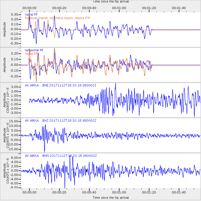
AMKA Regional Station, Amchitka Island, Alaska - Earthquake Result Viewer
*The percent match for this event was below the threshold and hence no stack was calculated.
| Earthquake location: |
Iran-Iraq Border Region |
| Earthquake latitude/longitude: |
34.9/46.0 |
| Earthquake time(UTC): |
2017/11/12 (316) 18:18:17 GMT |
| Earthquake Depth: |
19 km |
| Earthquake Magnitude: |
7.3 Mww |
| Earthquake Catalog/Contributor: |
NEIC PDE/us |
|
| Network: |
AV Alaska Volcano Observatory |
| Station: |
AMKA Regional Station, Amchitka Island, Alaska |
| Lat/Lon: |
51.38 N/179.30 E |
| Elevation: |
116 m |
|
| Distance: |
84.8 deg |
| Az: |
27.235 deg |
| Baz: |
323.119 deg |
| Ray Param: |
$rayparam |
*The percent match for this event was below the threshold and hence was not used in the summary stack. |
|
| Radial Match: |
78.26847 % |
| Radial Bump: |
400 |
| Transverse Match: |
76.86095 % |
| Transverse Bump: |
400 |
| SOD ConfigId: |
13570011 |
| Insert Time: |
2019-04-29 04:26:40.036 +0000 |
| GWidth: |
2.5 |
| Max Bumps: |
400 |
| Tol: |
0.001 |
|
Signal To Noise
| Channel | StoN | STA | LTA |
| AV:AMKA: :BHZ:20171112T18:30:18.980002Z | 6.51831 | 2.6221971E-6 | 4.0228173E-7 |
| AV:AMKA: :BHN:20171112T18:30:18.980002Z | 1.9291505 | 6.5701823E-7 | 3.4057388E-7 |
| AV:AMKA: :BHE:20171112T18:30:18.980002Z | 1.8832334 | 5.858654E-7 | 3.1109545E-7 |
| Arrivals |
| Ps | |
| PpPs | |
| PsPs/PpSs | |


