You are here: Home > Network List > AV - Alaska Volcano Observatory Stations List
> Station ANCK Angle Creek, Katmai Volcanic Cluster, Alaska > Earthquake Result Viewer
ANCK Angle Creek, Katmai Volcanic Cluster, Alaska - Earthquake Result Viewer
| Earthquake location: |
Iran-Iraq Border Region |
| Earthquake latitude/longitude: |
34.9/46.0 |
| Earthquake time(UTC): |
2017/11/12 (316) 18:18:17 GMT |
| Earthquake Depth: |
19 km |
| Earthquake Magnitude: |
7.3 Mww |
| Earthquake Catalog/Contributor: |
NEIC PDE/us |
|
| Network: |
AV Alaska Volcano Observatory |
| Station: |
ANCK Angle Creek, Katmai Volcanic Cluster, Alaska |
| Lat/Lon: |
58.20 N/155.50 W |
| Elevation: |
869 m |
|
| Distance: |
85.5 deg |
| Az: |
11.202 deg |
| Baz: |
342.452 deg |
| Ray Param: |
0.044690832 |
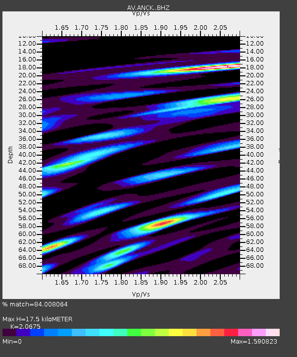
| Estimated Moho Depth: |
17.5 km |
| Estimated Crust Vp/Vs: |
2.07 |
| Assumed Crust Vp: |
6.438 km/s |
| Estimated Crust Vs: |
3.114 km/s |
| Estimated Crust Poisson's Ratio: |
0.35 |
|
| Radial Match: |
84.008064 % |
| Radial Bump: |
400 |
| Transverse Match: |
82.31815 % |
| Transverse Bump: |
400 |
| SOD ConfigId: |
13570011 |
| Insert Time: |
2019-04-29 04:26:40.502 +0000 |
| GWidth: |
2.5 |
| Max Bumps: |
400 |
| Tol: |
0.001 |
|
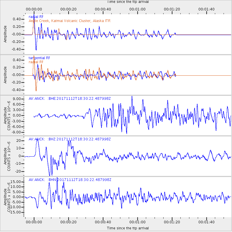
Signal To Noise
| Channel | StoN | STA | LTA |
| AV:ANCK: :BHZ:20171112T18:30:22.487998Z | 27.56703 | 1.1107126E-5 | 4.029134E-7 |
| AV:ANCK: :BHN:20171112T18:30:22.487998Z | 9.348475 | 4.584977E-6 | 4.9045184E-7 |
| AV:ANCK: :BHE:20171112T18:30:22.487998Z | 5.2556615 | 2.723467E-6 | 5.1819677E-7 |
| Arrivals |
| Ps | 3.0 SECOND |
| PpPs | 8.2 SECOND |
| PsPs/PpSs | 11 SECOND |


