You are here: Home > Network List > AV - Alaska Volcano Observatory Stations List
> Station AUJA Augustine Junction, Augustine Volcano, Alaska > Earthquake Result Viewer
AUJA Augustine Junction, Augustine Volcano, Alaska - Earthquake Result Viewer
| Earthquake location: |
Iran-Iraq Border Region |
| Earthquake latitude/longitude: |
34.9/46.0 |
| Earthquake time(UTC): |
2017/11/12 (316) 18:18:17 GMT |
| Earthquake Depth: |
19 km |
| Earthquake Magnitude: |
7.3 Mww |
| Earthquake Catalog/Contributor: |
NEIC PDE/us |
|
| Network: |
AV Alaska Volcano Observatory |
| Station: |
AUJA Augustine Junction, Augustine Volcano, Alaska |
| Lat/Lon: |
59.34 N/153.42 W |
| Elevation: |
376 m |
|
| Distance: |
84.7 deg |
| Az: |
9.833 deg |
| Baz: |
344.105 deg |
| Ray Param: |
0.04525514 |
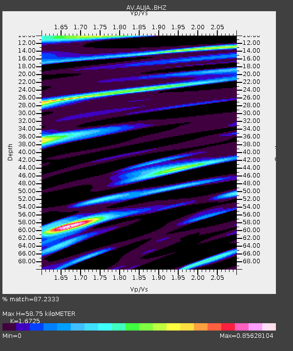
| Estimated Moho Depth: |
58.75 km |
| Estimated Crust Vp/Vs: |
1.67 |
| Assumed Crust Vp: |
5.989 km/s |
| Estimated Crust Vs: |
3.581 km/s |
| Estimated Crust Poisson's Ratio: |
0.22 |
|
| Radial Match: |
87.2333 % |
| Radial Bump: |
400 |
| Transverse Match: |
79.52817 % |
| Transverse Bump: |
400 |
| SOD ConfigId: |
13570011 |
| Insert Time: |
2019-04-29 04:26:41.812 +0000 |
| GWidth: |
2.5 |
| Max Bumps: |
400 |
| Tol: |
0.001 |
|

Signal To Noise
| Channel | StoN | STA | LTA |
| AV:AUJA: :BHZ:20171112T18:30:18.558982Z | 7.2709775 | 1.0575769E-5 | 1.4545183E-6 |
| AV:AUJA: :BHN:20171112T18:30:18.558982Z | 2.7413132 | 2.936775E-6 | 1.0713022E-6 |
| AV:AUJA: :BHE:20171112T18:30:18.558982Z | 1.4648246 | 2.1669587E-6 | 1.47933E-6 |
| Arrivals |
| Ps | 6.7 SECOND |
| PpPs | 26 SECOND |
| PsPs/PpSs | 32 SECOND |


