You are here: Home > Network List > AV - Alaska Volcano Observatory Stations List
> Station MAPS Pakushin Southeast, Makushin Volcano, Alaska > Earthquake Result Viewer
MAPS Pakushin Southeast, Makushin Volcano, Alaska - Earthquake Result Viewer
| Earthquake location: |
Iran-Iraq Border Region |
| Earthquake latitude/longitude: |
34.9/46.0 |
| Earthquake time(UTC): |
2017/11/12 (316) 18:18:17 GMT |
| Earthquake Depth: |
19 km |
| Earthquake Magnitude: |
7.3 Mww |
| Earthquake Catalog/Contributor: |
NEIC PDE/us |
|
| Network: |
AV Alaska Volcano Observatory |
| Station: |
MAPS Pakushin Southeast, Makushin Volcano, Alaska |
| Lat/Lon: |
53.81 N/166.94 W |
| Elevation: |
333 m |
|
| Distance: |
87.2 deg |
| Az: |
18.815 deg |
| Baz: |
333.452 deg |
| Ray Param: |
0.043500565 |
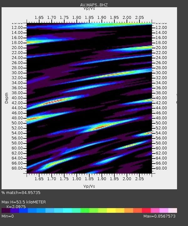
| Estimated Moho Depth: |
53.5 km |
| Estimated Crust Vp/Vs: |
2.10 |
| Assumed Crust Vp: |
3.943 km/s |
| Estimated Crust Vs: |
1.88 km/s |
| Estimated Crust Poisson's Ratio: |
0.35 |
|
| Radial Match: |
84.95735 % |
| Radial Bump: |
400 |
| Transverse Match: |
86.68373 % |
| Transverse Bump: |
400 |
| SOD ConfigId: |
13570011 |
| Insert Time: |
2019-04-29 04:26:49.816 +0000 |
| GWidth: |
2.5 |
| Max Bumps: |
400 |
| Tol: |
0.001 |
|

Signal To Noise
| Channel | StoN | STA | LTA |
| AV:MAPS: :BHZ:20171112T18:30:30.558982Z | 17.376501 | 6.7727383E-6 | 3.897642E-7 |
| AV:MAPS: :BHN:20171112T18:30:30.558982Z | 4.2489104 | 1.9391873E-6 | 4.5639638E-7 |
| AV:MAPS: :BHE:20171112T18:30:30.558982Z | 4.3967037 | 1.7753626E-6 | 4.0379402E-7 |
| Arrivals |
| Ps | 15 SECOND |
| PpPs | 42 SECOND |
| PsPs/PpSs | 57 SECOND |


