You are here: Home > Network List > US - United States National Seismic Network Stations List
> Station AMTX Amarillo, Texas, USA > Earthquake Result Viewer
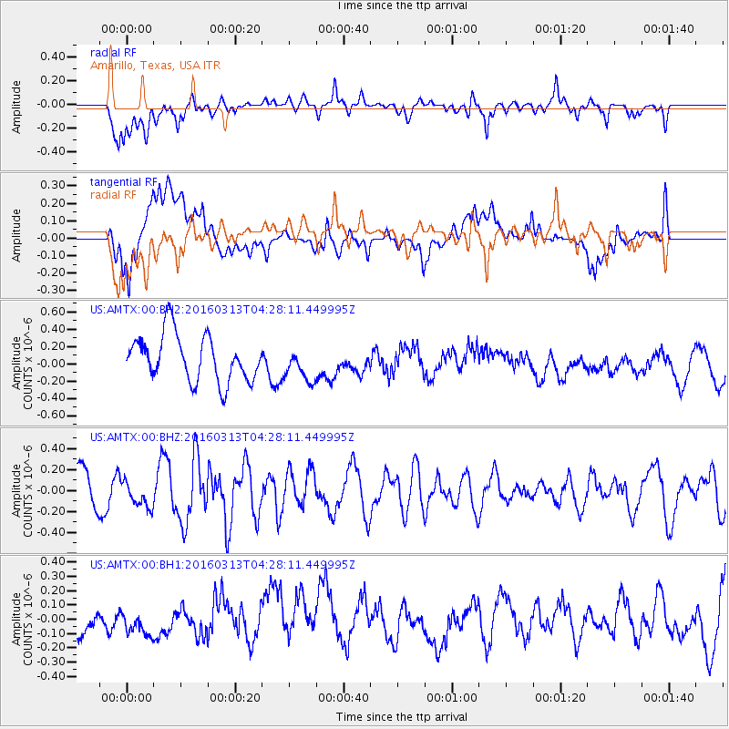
AMTX Amarillo, Texas, USA - Earthquake Result Viewer
*The percent match for this event was below the threshold and hence no stack was calculated.
| Earthquake location: |
Andreanof Islands, Aleutian Is. |
| Earthquake latitude/longitude: |
51.5/-173.9 |
| Earthquake time(UTC): |
2016/03/13 (073) 04:19:25 GMT |
| Earthquake Depth: |
10 km |
| Earthquake Magnitude: |
5.5 MWC, 4.7 ML, 5.4 MB, 5.5 MWC |
| Earthquake Catalog/Contributor: |
NEIC PDE/NEIC COMCAT |
|
| Network: |
US United States National Seismic Network |
| Station: |
AMTX Amarillo, Texas, USA |
| Lat/Lon: |
34.53 N/101.41 W |
| Elevation: |
1010 m |
|
| Distance: |
53.4 deg |
| Az: |
78.646 deg |
| Baz: |
312.14 deg |
| Ray Param: |
$rayparam |
*The percent match for this event was below the threshold and hence was not used in the summary stack. |
|
| Radial Match: |
56.50693 % |
| Radial Bump: |
400 |
| Transverse Match: |
47.54611 % |
| Transverse Bump: |
400 |
| SOD ConfigId: |
1475611 |
| Insert Time: |
2016-04-16 00:24:06.941 +0000 |
| GWidth: |
2.5 |
| Max Bumps: |
400 |
| Tol: |
0.001 |
|
Signal To Noise
| Channel | StoN | STA | LTA |
| US:AMTX:00:BHZ:20160313T04:28:11.449995Z | 0.5886611 | 1.314587E-7 | 2.2331817E-7 |
| US:AMTX:00:BH1:20160313T04:28:11.449995Z | 0.53273857 | 8.232705E-8 | 1.5453554E-7 |
| US:AMTX:00:BH2:20160313T04:28:11.449995Z | 0.74869776 | 2.035389E-7 | 2.7185723E-7 |
| Arrivals |
| Ps | |
| PpPs | |
| PsPs/PpSs | |


