You are here: Home > Network List > AV - Alaska Volcano Observatory Stations List
> Station WEBT Beartrack Creek, Westdahl Peak, Alaska > Earthquake Result Viewer
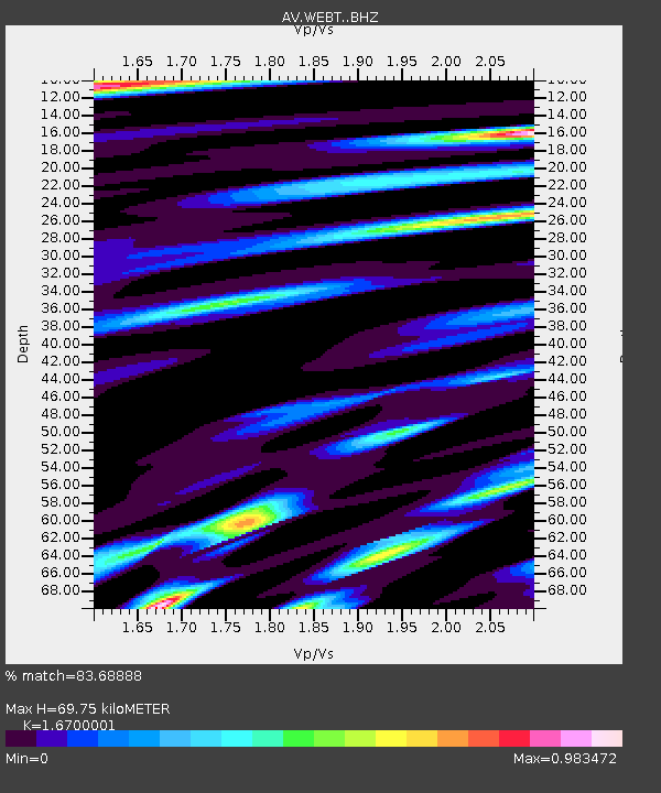
WEBT Beartrack Creek, Westdahl Peak, Alaska - Earthquake Result Viewer
| Earthquake location: |
Iran-Iraq Border Region |
| Earthquake latitude/longitude: |
34.9/46.0 |
| Earthquake time(UTC): |
2017/11/12 (316) 18:18:17 GMT |
| Earthquake Depth: |
19 km |
| Earthquake Magnitude: |
7.3 Mww |
| Earthquake Catalog/Contributor: |
NEIC PDE/us |
|
| Network: |
AV Alaska Volcano Observatory |
| Station: |
WEBT Beartrack Creek, Westdahl Peak, Alaska |
| Lat/Lon: |
54.59 N/164.76 W |
| Elevation: |
467 m |
|
| Distance: |
87.0 deg |
| Az: |
17.316 deg |
| Baz: |
335.145 deg |
| Ray Param: |
0.043609794 |
| Estimated Moho Depth: |
69.75 km |
| Estimated Crust Vp/Vs: |
1.67 |
| Assumed Crust Vp: |
5.989 km/s |
| Estimated Crust Vs: |
3.586 km/s |
| Estimated Crust Poisson's Ratio: |
0.22 |
|
| Radial Match: |
83.68888 % |
| Radial Bump: |
400 |
| Transverse Match: |
71.62602 % |
| Transverse Bump: |
400 |
| SOD ConfigId: |
13570011 |
| Insert Time: |
2019-04-29 04:27:09.243 +0000 |
| GWidth: |
2.5 |
| Max Bumps: |
400 |
| Tol: |
0.001 |
|

Signal To Noise
| Channel | StoN | STA | LTA |
| AV:WEBT: :BHZ:20171112T18:30:29.839988Z | 22.044268 | 1.2502587E-5 | 5.671582E-7 |
| AV:WEBT: :BHN:20171112T18:30:29.839988Z | 8.653424 | 4.113388E-6 | 4.7534803E-7 |
| AV:WEBT: :BHE:20171112T18:30:29.839988Z | 4.175852 | 2.5277868E-6 | 6.053344E-7 |
| Arrivals |
| Ps | 8.0 SECOND |
| PpPs | 30 SECOND |
| PsPs/PpSs | 38 SECOND |


