You are here: Home > Network List > CA - Catalan Seismic Network Stations List
> Station CLLI Llivia > Earthquake Result Viewer
CLLI Llivia - Earthquake Result Viewer
| Earthquake location: |
Iran-Iraq Border Region |
| Earthquake latitude/longitude: |
34.9/46.0 |
| Earthquake time(UTC): |
2017/11/12 (316) 18:18:17 GMT |
| Earthquake Depth: |
19 km |
| Earthquake Magnitude: |
7.3 Mww |
| Earthquake Catalog/Contributor: |
NEIC PDE/us |
|
| Network: |
CA Catalan Seismic Network |
| Station: |
CLLI Llivia |
| Lat/Lon: |
42.48 N/1.97 E |
| Elevation: |
1413 m |
|
| Distance: |
34.8 deg |
| Az: |
295.929 deg |
| Baz: |
87.642 deg |
| Ray Param: |
0.07751401 |
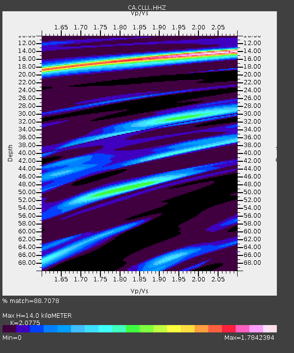
| Estimated Moho Depth: |
14.0 km |
| Estimated Crust Vp/Vs: |
2.08 |
| Assumed Crust Vp: |
6.416 km/s |
| Estimated Crust Vs: |
3.088 km/s |
| Estimated Crust Poisson's Ratio: |
0.35 |
|
| Radial Match: |
88.7078 % |
| Radial Bump: |
345 |
| Transverse Match: |
59.679615 % |
| Transverse Bump: |
400 |
| SOD ConfigId: |
13570011 |
| Insert Time: |
2019-04-29 04:27:20.969 +0000 |
| GWidth: |
2.5 |
| Max Bumps: |
400 |
| Tol: |
0.001 |
|

Signal To Noise
| Channel | StoN | STA | LTA |
| CA:CLLI: :HHZ:20171112T18:24:36.309989Z | 13.770626 | 3.6678493E-6 | 2.6635314E-7 |
| CA:CLLI: :HHN:20171112T18:24:36.309989Z | 1.2109318 | 3.142491E-7 | 2.5951016E-7 |
| CA:CLLI: :HHE:20171112T18:24:36.309989Z | 16.497667 | 2.4885467E-6 | 1.5084234E-7 |
| Arrivals |
| Ps | 2.5 SECOND |
| PpPs | 6.3 SECOND |
| PsPs/PpSs | 8.8 SECOND |


