You are here: Home > Network List > CA - Catalan Seismic Network Stations List
> Station EBR Ebre > Earthquake Result Viewer
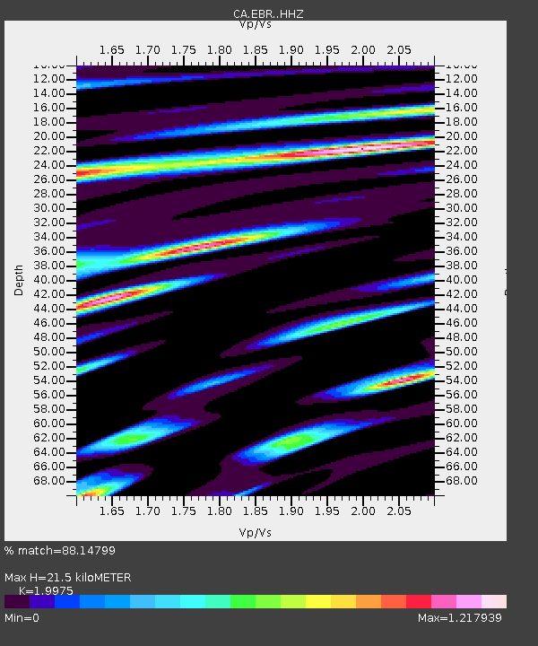
EBR Ebre - Earthquake Result Viewer
| Earthquake location: |
Iran-Iraq Border Region |
| Earthquake latitude/longitude: |
34.9/46.0 |
| Earthquake time(UTC): |
2017/11/12 (316) 18:18:17 GMT |
| Earthquake Depth: |
19 km |
| Earthquake Magnitude: |
7.3 Mww |
| Earthquake Catalog/Contributor: |
NEIC PDE/us |
|
| Network: |
CA Catalan Seismic Network |
| Station: |
EBR Ebre |
| Lat/Lon: |
40.82 N/0.49 E |
| Elevation: |
36 m |
|
| Distance: |
36.1 deg |
| Az: |
293.211 deg |
| Baz: |
84.449 deg |
| Ray Param: |
0.07686569 |
| Estimated Moho Depth: |
21.5 km |
| Estimated Crust Vp/Vs: |
2.00 |
| Assumed Crust Vp: |
6.391 km/s |
| Estimated Crust Vs: |
3.199 km/s |
| Estimated Crust Poisson's Ratio: |
0.33 |
|
| Radial Match: |
88.14799 % |
| Radial Bump: |
400 |
| Transverse Match: |
83.412056 % |
| Transverse Bump: |
400 |
| SOD ConfigId: |
13570011 |
| Insert Time: |
2019-04-29 04:27:24.428 +0000 |
| GWidth: |
2.5 |
| Max Bumps: |
400 |
| Tol: |
0.001 |
|

Signal To Noise
| Channel | StoN | STA | LTA |
| CA:EBR: :HHZ:20171112T18:24:46.77999Z | 12.736707 | 5.344338E-6 | 4.1960124E-7 |
| CA:EBR: :HHN:20171112T18:24:46.77999Z | 2.3669991 | 1.4824283E-6 | 6.2629016E-7 |
| CA:EBR: :HHE:20171112T18:24:46.77999Z | 6.830344 | 3.5344779E-6 | 5.17467E-7 |
| Arrivals |
| Ps | 3.6 SECOND |
| PpPs | 9.4 SECOND |
| PsPs/PpSs | 13 SECOND |


