You are here: Home > Network List > CN - Canadian National Seismograph Network Stations List
> Station A16 Riviere Ouelle, QC, CA > Earthquake Result Viewer
A16 Riviere Ouelle, QC, CA - Earthquake Result Viewer
| Earthquake location: |
Iran-Iraq Border Region |
| Earthquake latitude/longitude: |
34.9/46.0 |
| Earthquake time(UTC): |
2017/11/12 (316) 18:18:17 GMT |
| Earthquake Depth: |
19 km |
| Earthquake Magnitude: |
7.3 Mww |
| Earthquake Catalog/Contributor: |
NEIC PDE/us |
|
| Network: |
CN Canadian National Seismograph Network |
| Station: |
A16 Riviere Ouelle, QC, CA |
| Lat/Lon: |
47.47 N/70.01 W |
| Elevation: |
13 m |
|
| Distance: |
80.0 deg |
| Az: |
321.723 deg |
| Baz: |
48.627 deg |
| Ray Param: |
0.04858645 |
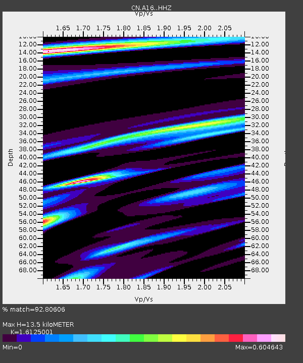
| Estimated Moho Depth: |
13.5 km |
| Estimated Crust Vp/Vs: |
1.61 |
| Assumed Crust Vp: |
6.61 km/s |
| Estimated Crust Vs: |
4.099 km/s |
| Estimated Crust Poisson's Ratio: |
0.19 |
|
| Radial Match: |
92.80606 % |
| Radial Bump: |
400 |
| Transverse Match: |
86.90784 % |
| Transverse Bump: |
400 |
| SOD ConfigId: |
13570011 |
| Insert Time: |
2019-04-29 04:27:29.873 +0000 |
| GWidth: |
2.5 |
| Max Bumps: |
400 |
| Tol: |
0.001 |
|

Signal To Noise
| Channel | StoN | STA | LTA |
| CN:A16: :HHZ:20171112T18:29:53.709983Z | 13.558083 | 8.579608E-6 | 6.3280396E-7 |
| CN:A16: :HHN:20171112T18:29:53.709983Z | 3.4244416 | 2.492742E-6 | 7.2792653E-7 |
| CN:A16: :HHE:20171112T18:29:53.709983Z | 5.2141266 | 2.8496033E-6 | 5.4651593E-7 |
| Arrivals |
| Ps | 1.3 SECOND |
| PpPs | 5.2 SECOND |
| PsPs/PpSs | 6.5 SECOND |


