You are here: Home > Network List > TA - USArray Transportable Network (new EarthScope stations) Stations List
> Station D18A Linhart Farms, Moccasin, MT, USA > Earthquake Result Viewer
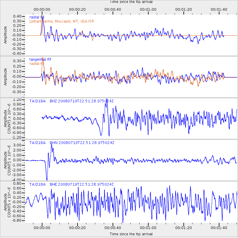
D18A Linhart Farms, Moccasin, MT, USA - Earthquake Result Viewer
*The percent match for this event was below the threshold and hence no stack was calculated.
| Earthquake location: |
Fiji Islands Region |
| Earthquake latitude/longitude: |
-17.3/-177.3 |
| Earthquake time(UTC): |
2008/07/19 (201) 22:39:52 GMT |
| Earthquake Depth: |
391 km |
| Earthquake Magnitude: |
5.9 MB, 6.4 MW, 6.4 MW |
| Earthquake Catalog/Contributor: |
WHDF/NEIC |
|
| Network: |
TA USArray Transportable Network (new EarthScope stations) |
| Station: |
D18A Linhart Farms, Moccasin, MT, USA |
| Lat/Lon: |
47.20 N/109.80 W |
| Elevation: |
1202 m |
|
| Distance: |
88.1 deg |
| Az: |
39.081 deg |
| Baz: |
242.001 deg |
| Ray Param: |
$rayparam |
*The percent match for this event was below the threshold and hence was not used in the summary stack. |
|
| Radial Match: |
77.07065 % |
| Radial Bump: |
400 |
| Transverse Match: |
60.70191 % |
| Transverse Bump: |
400 |
| SOD ConfigId: |
2504 |
| Insert Time: |
2010-03-06 06:14:33.489 +0000 |
| GWidth: |
2.5 |
| Max Bumps: |
400 |
| Tol: |
0.001 |
|
Signal To Noise
| Channel | StoN | STA | LTA |
| TA:D18A: :BHN:20080719T22:51:28.975024Z | 23.374208 | 1.4556495E-6 | 6.227589E-8 |
| TA:D18A: :BHE:20080719T22:51:28.975024Z | 2.106066 | 3.222274E-7 | 1.5299966E-7 |
| TA:D18A: :BHZ:20080719T22:51:28.975024Z | 6.5162163 | 5.5707864E-7 | 8.549112E-8 |
| Arrivals |
| Ps | |
| PpPs | |
| PsPs/PpSs | |


