You are here: Home > Network List > CN - Canadian National Seismograph Network Stations List
> Station SADO Sadowa, ON, CA > Earthquake Result Viewer
SADO Sadowa, ON, CA - Earthquake Result Viewer

| Earthquake location: |
Iran-Iraq Border Region |
| Earthquake latitude/longitude: |
34.9/46.0 |
| Earthquake time(UTC): |
2017/11/12 (316) 18:18:17 GMT |
| Earthquake Depth: |
19 km |
| Earthquake Magnitude: |
7.3 Mww |
| Earthquake Catalog/Contributor: |
NEIC PDE/us |
|
| Network: |
CN Canadian National Seismograph Network |
| Station: |
SADO Sadowa, ON, CA |
| Lat/Lon: |
44.77 N/79.14 W |
| Elevation: |
228 m |
|
| Distance: |
86.4 deg |
| Az: |
324.27 deg |
| Baz: |
42.361 deg |
| Ray Param: |
0.044080332 |
| Estimated Moho Depth: |
39.75 km |
| Estimated Crust Vp/Vs: |
1.72 |
| Assumed Crust Vp: |
6.577 km/s |
| Estimated Crust Vs: |
3.818 km/s |
| Estimated Crust Poisson's Ratio: |
0.25 |
|
| Radial Match: |
91.611694 % |
| Radial Bump: |
319 |
| Transverse Match: |
80.29674 % |
| Transverse Bump: |
400 |
| SOD ConfigId: |
13570011 |
| Insert Time: |
2019-04-29 04:28:02.840 +0000 |
| GWidth: |
2.5 |
| Max Bumps: |
400 |
| Tol: |
0.001 |
|
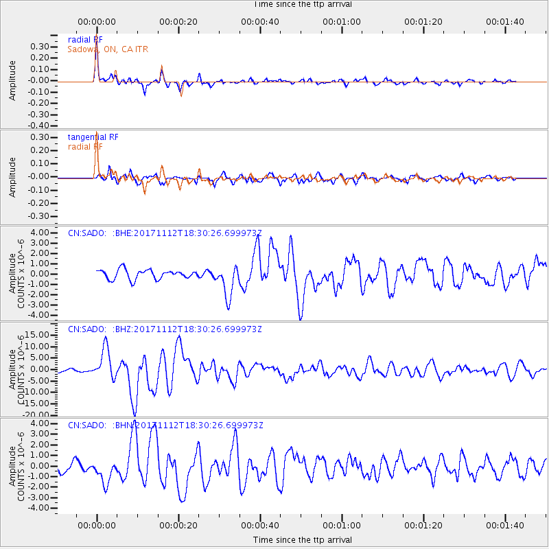
Signal To Noise
| Channel | StoN | STA | LTA |
| CN:SADO: :BHZ:20171112T18:30:26.699973Z | 10.308008 | 6.9081043E-6 | 6.7016873E-7 |
| CN:SADO: :BHN:20171112T18:30:26.699973Z | 2.1342206 | 1.1757178E-6 | 5.508886E-7 |
| CN:SADO: :BHE:20171112T18:30:26.699973Z | 3.4337492 | 1.5716663E-6 | 4.5771148E-7 |
| Arrivals |
| Ps | 4.5 SECOND |
| PpPs | 16 SECOND |
| PsPs/PpSs | 21 SECOND |


