You are here: Home > Network List > CN - Canadian National Seismograph Network Stations List
> Station RES Resolute, NU, CA > Earthquake Result Viewer
RES Resolute, NU, CA - Earthquake Result Viewer

| Earthquake location: |
Iran-Iraq Border Region |
| Earthquake latitude/longitude: |
34.9/46.0 |
| Earthquake time(UTC): |
2017/11/12 (316) 18:18:17 GMT |
| Earthquake Depth: |
19 km |
| Earthquake Magnitude: |
7.3 Mww |
| Earthquake Catalog/Contributor: |
NEIC PDE/us |
|
| Network: |
CN Canadian National Seismograph Network |
| Station: |
RES Resolute, NU, CA |
| Lat/Lon: |
74.69 N/94.90 W |
| Elevation: |
19 m |
|
| Distance: |
67.7 deg |
| Az: |
349.552 deg |
| Baz: |
34.119 deg |
| Ray Param: |
0.056780867 |
| Estimated Moho Depth: |
18.5 km |
| Estimated Crust Vp/Vs: |
1.62 |
| Assumed Crust Vp: |
6.367 km/s |
| Estimated Crust Vs: |
3.942 km/s |
| Estimated Crust Poisson's Ratio: |
0.19 |
|
| Radial Match: |
97.44403 % |
| Radial Bump: |
400 |
| Transverse Match: |
91.37169 % |
| Transverse Bump: |
400 |
| SOD ConfigId: |
13570011 |
| Insert Time: |
2019-04-29 04:28:03.601 +0000 |
| GWidth: |
2.5 |
| Max Bumps: |
400 |
| Tol: |
0.001 |
|
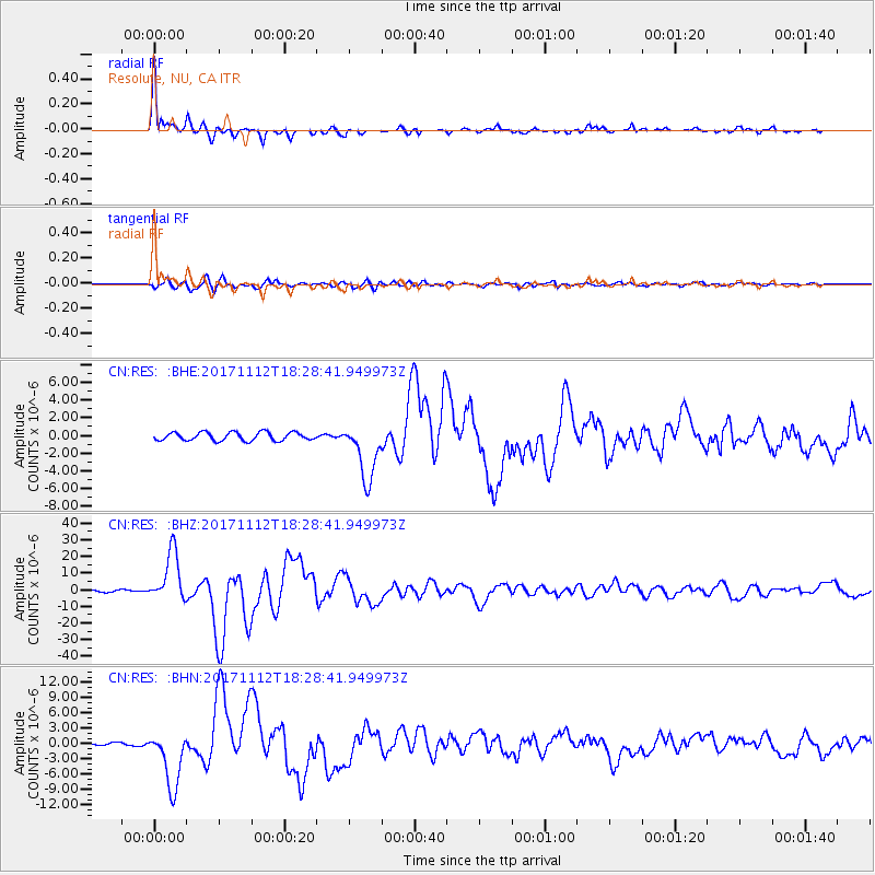
Signal To Noise
| Channel | StoN | STA | LTA |
| CN:RES: :BHZ:20171112T18:28:41.949973Z | 22.193829 | 1.5149881E-5 | 6.826168E-7 |
| CN:RES: :BHN:20171112T18:28:41.949973Z | 15.86678 | 5.693395E-6 | 3.5882485E-7 |
| CN:RES: :BHE:20171112T18:28:41.949973Z | 6.997655 | 3.274574E-6 | 4.6795307E-7 |
| Arrivals |
| Ps | 1.9 SECOND |
| PpPs | 7.3 SECOND |
| PsPs/PpSs | 9.1 SECOND |


