You are here: Home > Network List > DK - Danish Seismological Network Stations List
> Station ILULI Ilulissat, Greenland > Earthquake Result Viewer
ILULI Ilulissat, Greenland - Earthquake Result Viewer
| Earthquake location: |
Iran-Iraq Border Region |
| Earthquake latitude/longitude: |
34.9/46.0 |
| Earthquake time(UTC): |
2017/11/12 (316) 18:18:17 GMT |
| Earthquake Depth: |
19 km |
| Earthquake Magnitude: |
7.3 Mww |
| Earthquake Catalog/Contributor: |
NEIC PDE/us |
|
| Network: |
DK Danish Seismological Network |
| Station: |
ILULI Ilulissat, Greenland |
| Lat/Lon: |
69.21 N/51.10 W |
| Elevation: |
54 m |
|
| Distance: |
60.3 deg |
| Az: |
335.919 deg |
| Baz: |
69.947 deg |
| Ray Param: |
0.061628092 |
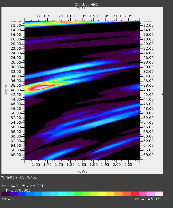
| Estimated Moho Depth: |
38.75 km |
| Estimated Crust Vp/Vs: |
1.67 |
| Assumed Crust Vp: |
6.459 km/s |
| Estimated Crust Vs: |
3.868 km/s |
| Estimated Crust Poisson's Ratio: |
0.22 |
|
| Radial Match: |
85.76451 % |
| Radial Bump: |
400 |
| Transverse Match: |
68.54876 % |
| Transverse Bump: |
400 |
| SOD ConfigId: |
13570011 |
| Insert Time: |
2019-04-29 04:28:22.968 +0000 |
| GWidth: |
2.5 |
| Max Bumps: |
400 |
| Tol: |
0.001 |
|

Signal To Noise
| Channel | StoN | STA | LTA |
| DK:ILULI: :HHZ:20171112T18:27:53.287986Z | 11.125909 | 1.10251085E-5 | 9.9094E-7 |
| DK:ILULI: :HHN:20171112T18:27:53.287986Z | 2.503777 | 2.1778396E-6 | 8.698217E-7 |
| DK:ILULI: :HHE:20171112T18:27:53.287986Z | 5.1991577 | 6.833622E-6 | 1.3143709E-6 |
| Arrivals |
| Ps | 4.2 SECOND |
| PpPs | 15 SECOND |
| PsPs/PpSs | 19 SECOND |


