You are here: Home > Network List > DK - Danish Seismological Network Stations List
> Station NOR Station Nord, Greenland > Earthquake Result Viewer
NOR Station Nord, Greenland - Earthquake Result Viewer
| Earthquake location: |
Iran-Iraq Border Region |
| Earthquake latitude/longitude: |
34.9/46.0 |
| Earthquake time(UTC): |
2017/11/12 (316) 18:18:17 GMT |
| Earthquake Depth: |
19 km |
| Earthquake Magnitude: |
7.3 Mww |
| Earthquake Catalog/Contributor: |
NEIC PDE/us |
|
| Network: |
DK Danish Seismological Network |
| Station: |
NOR Station Nord, Greenland |
| Lat/Lon: |
81.60 N/16.66 W |
| Elevation: |
36 m |
|
| Distance: |
51.8 deg |
| Az: |
350.436 deg |
| Baz: |
111.685 deg |
| Ray Param: |
0.06718197 |
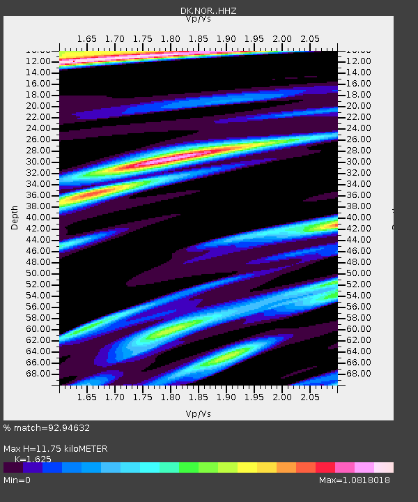
| Estimated Moho Depth: |
11.75 km |
| Estimated Crust Vp/Vs: |
1.62 |
| Assumed Crust Vp: |
6.459 km/s |
| Estimated Crust Vs: |
3.975 km/s |
| Estimated Crust Poisson's Ratio: |
0.20 |
|
| Radial Match: |
92.94632 % |
| Radial Bump: |
393 |
| Transverse Match: |
85.668785 % |
| Transverse Bump: |
392 |
| SOD ConfigId: |
13570011 |
| Insert Time: |
2019-04-29 04:28:23.916 +0000 |
| GWidth: |
2.5 |
| Max Bumps: |
400 |
| Tol: |
0.001 |
|

Signal To Noise
| Channel | StoN | STA | LTA |
| DK:NOR: :HHZ:20171112T18:26:52.558982Z | 33.110497 | 1.697214E-5 | 5.12591E-7 |
| DK:NOR: :HHN:20171112T18:26:52.558982Z | 14.008481 | 4.2015213E-6 | 2.9992697E-7 |
| DK:NOR: :HHE:20171112T18:26:52.558982Z | 16.198738 | 8.624729E-6 | 5.324321E-7 |
| Arrivals |
| Ps | 1.2 SECOND |
| PpPs | 4.5 SECOND |
| PsPs/PpSs | 5.7 SECOND |


