You are here: Home > Network List > EI - Irish National Seismic Network (INSN) Stations List
> Station IGLA GLENGOWLA, CO GALWAY, IRELAND > Earthquake Result Viewer
IGLA GLENGOWLA, CO GALWAY, IRELAND - Earthquake Result Viewer
| Earthquake location: |
Iran-Iraq Border Region |
| Earthquake latitude/longitude: |
34.9/46.0 |
| Earthquake time(UTC): |
2017/11/12 (316) 18:18:17 GMT |
| Earthquake Depth: |
19 km |
| Earthquake Magnitude: |
7.3 Mww |
| Earthquake Catalog/Contributor: |
NEIC PDE/us |
|
| Network: |
EI Irish National Seismic Network (INSN) |
| Station: |
IGLA GLENGOWLA, CO GALWAY, IRELAND |
| Lat/Lon: |
53.42 N/9.38 W |
| Elevation: |
31 m |
|
| Distance: |
42.6 deg |
| Az: |
313.337 deg |
| Baz: |
92.844 deg |
| Ray Param: |
0.07306253 |
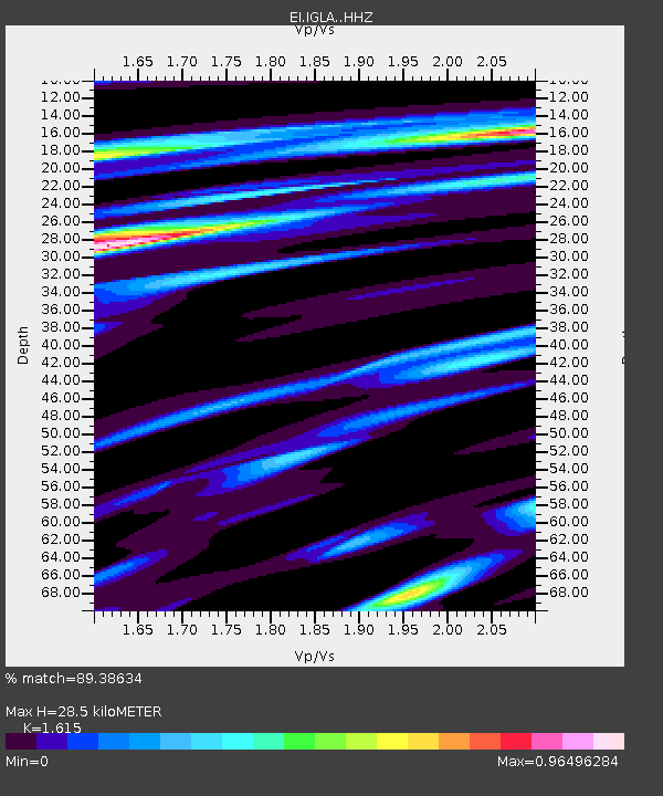
| Estimated Moho Depth: |
28.5 km |
| Estimated Crust Vp/Vs: |
1.62 |
| Assumed Crust Vp: |
6.276 km/s |
| Estimated Crust Vs: |
3.886 km/s |
| Estimated Crust Poisson's Ratio: |
0.19 |
|
| Radial Match: |
89.38634 % |
| Radial Bump: |
340 |
| Transverse Match: |
73.28135 % |
| Transverse Bump: |
400 |
| SOD ConfigId: |
13570011 |
| Insert Time: |
2019-04-29 04:28:27.167 +0000 |
| GWidth: |
2.5 |
| Max Bumps: |
400 |
| Tol: |
0.001 |
|

Signal To Noise
| Channel | StoN | STA | LTA |
| EI:IGLA: :HHZ:20171112T18:25:41.249991Z | 12.032681 | 1.264605E-5 | 1.0509752E-6 |
| EI:IGLA: :HHN:20171112T18:25:41.249991Z | 2.5264244 | 1.352291E-6 | 5.3525883E-7 |
| EI:IGLA: :HHE:20171112T18:25:41.249991Z | 9.159239 | 7.060738E-6 | 7.7088697E-7 |
| Arrivals |
| Ps | 3.0 SECOND |
| PpPs | 11 SECOND |
| PsPs/PpSs | 14 SECOND |


