You are here: Home > Network List > AG - Arkansas Seismic Network Stations List
> Station HHAR Hobbs,AR > Earthquake Result Viewer
HHAR Hobbs,AR - Earthquake Result Viewer
| Earthquake location: |
Alaska Peninsula |
| Earthquake latitude/longitude: |
57.0/-158.0 |
| Earthquake time(UTC): |
2016/04/02 (093) 05:50:00 GMT |
| Earthquake Depth: |
10 km |
| Earthquake Magnitude: |
6.2 MWP, 6.4 MI |
| Earthquake Catalog/Contributor: |
NEIC PDE/NEIC COMCAT |
|
| Network: |
AG Arkansas Seismic Network |
| Station: |
HHAR Hobbs,AR |
| Lat/Lon: |
36.28 N/93.94 W |
| Elevation: |
421 m |
|
| Distance: |
46.6 deg |
| Az: |
87.984 deg |
| Baz: |
317.464 deg |
| Ray Param: |
0.07053428 |
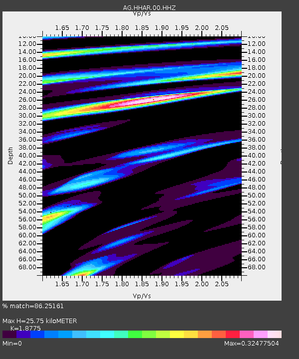
| Estimated Moho Depth: |
25.75 km |
| Estimated Crust Vp/Vs: |
1.88 |
| Assumed Crust Vp: |
6.53 km/s |
| Estimated Crust Vs: |
3.478 km/s |
| Estimated Crust Poisson's Ratio: |
0.30 |
|
| Radial Match: |
86.25161 % |
| Radial Bump: |
282 |
| Transverse Match: |
59.846813 % |
| Transverse Bump: |
400 |
| SOD ConfigId: |
1475611 |
| Insert Time: |
2016-04-16 05:50:18.394 +0000 |
| GWidth: |
2.5 |
| Max Bumps: |
400 |
| Tol: |
0.001 |
|

Signal To Noise
| Channel | StoN | STA | LTA |
| AG:HHAR:00:HHZ:20160402T05:57:57.999988Z | 7.447122 | 8.50927E-7 | 1.1426253E-7 |
| AG:HHAR:00:HHN:20160402T05:57:57.999988Z | 2.686703 | 2.977574E-7 | 1.1082631E-7 |
| AG:HHAR:00:HHE:20160402T05:57:57.999988Z | 2.4429617 | 3.5124415E-7 | 1.43778E-7 |
| Arrivals |
| Ps | 3.7 SECOND |
| PpPs | 11 SECOND |
| PsPs/PpSs | 14 SECOND |


