You are here: Home > Network List > GB - Great Britain Seismograph Network Stations List
> Station KPL PLOCKTON, SCOTLAND > Earthquake Result Viewer
KPL PLOCKTON, SCOTLAND - Earthquake Result Viewer
| Earthquake location: |
Iran-Iraq Border Region |
| Earthquake latitude/longitude: |
34.9/46.0 |
| Earthquake time(UTC): |
2017/11/12 (316) 18:18:17 GMT |
| Earthquake Depth: |
19 km |
| Earthquake Magnitude: |
7.3 Mww |
| Earthquake Catalog/Contributor: |
NEIC PDE/us |
|
| Network: |
GB Great Britain Seismograph Network |
| Station: |
KPL PLOCKTON, SCOTLAND |
| Lat/Lon: |
57.34 N/5.65 W |
| Elevation: |
13 m |
|
| Distance: |
40.9 deg |
| Az: |
319.565 deg |
| Baz: |
100.551 deg |
| Ray Param: |
0.07407802 |
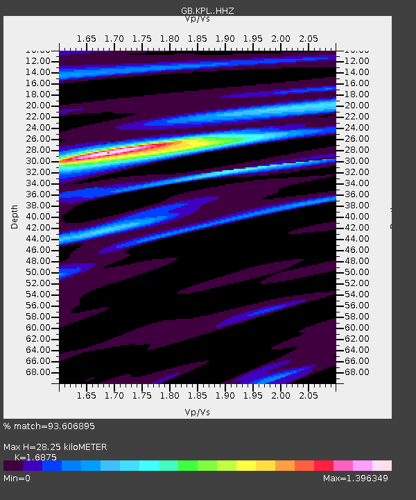
| Estimated Moho Depth: |
28.25 km |
| Estimated Crust Vp/Vs: |
1.69 |
| Assumed Crust Vp: |
6.276 km/s |
| Estimated Crust Vs: |
3.719 km/s |
| Estimated Crust Poisson's Ratio: |
0.23 |
|
| Radial Match: |
93.606895 % |
| Radial Bump: |
314 |
| Transverse Match: |
75.394485 % |
| Transverse Bump: |
400 |
| SOD ConfigId: |
13570011 |
| Insert Time: |
2019-04-29 04:28:42.635 +0000 |
| GWidth: |
2.5 |
| Max Bumps: |
400 |
| Tol: |
0.001 |
|

Signal To Noise
| Channel | StoN | STA | LTA |
| GB:KPL: :HHZ:20171112T18:25:27.730002Z | 10.437373 | 1.601114E-5 | 1.53402E-6 |
| GB:KPL: :HHN:20171112T18:25:27.730002Z | 2.6972518 | 2.7414667E-6 | 1.0163926E-6 |
| GB:KPL: :HHE:20171112T18:25:27.730002Z | 5.5664463 | 9.192669E-6 | 1.6514429E-6 |
| Arrivals |
| Ps | 3.3 SECOND |
| PpPs | 11 SECOND |
| PsPs/PpSs | 15 SECOND |


