You are here: Home > Network List > GT - Global Telemetered Seismograph Network (USAF/USGS) Stations List
> Station DBIC Dimbokro, Cote d'Ivoire > Earthquake Result Viewer
DBIC Dimbokro, Cote d'Ivoire - Earthquake Result Viewer
| Earthquake location: |
Iran-Iraq Border Region |
| Earthquake latitude/longitude: |
34.9/46.0 |
| Earthquake time(UTC): |
2017/11/12 (316) 18:18:17 GMT |
| Earthquake Depth: |
19 km |
| Earthquake Magnitude: |
7.3 Mww |
| Earthquake Catalog/Contributor: |
NEIC PDE/us |
|
| Network: |
GT Global Telemetered Seismograph Network (USAF/USGS) |
| Station: |
DBIC Dimbokro, Cote d'Ivoire |
| Lat/Lon: |
6.67 N/4.86 W |
| Elevation: |
125 m |
|
| Distance: |
54.4 deg |
| Az: |
251.161 deg |
| Baz: |
51.545 deg |
| Ray Param: |
0.06542696 |
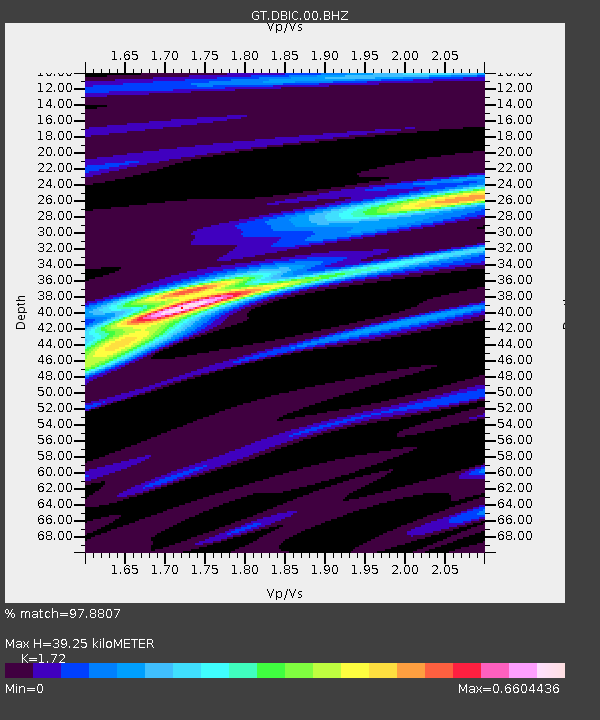
| Estimated Moho Depth: |
39.25 km |
| Estimated Crust Vp/Vs: |
1.72 |
| Assumed Crust Vp: |
6.419 km/s |
| Estimated Crust Vs: |
3.732 km/s |
| Estimated Crust Poisson's Ratio: |
0.24 |
|
| Radial Match: |
97.8807 % |
| Radial Bump: |
266 |
| Transverse Match: |
95.51785 % |
| Transverse Bump: |
400 |
| SOD ConfigId: |
13570011 |
| Insert Time: |
2019-04-29 04:28:54.959 +0000 |
| GWidth: |
2.5 |
| Max Bumps: |
400 |
| Tol: |
0.001 |
|
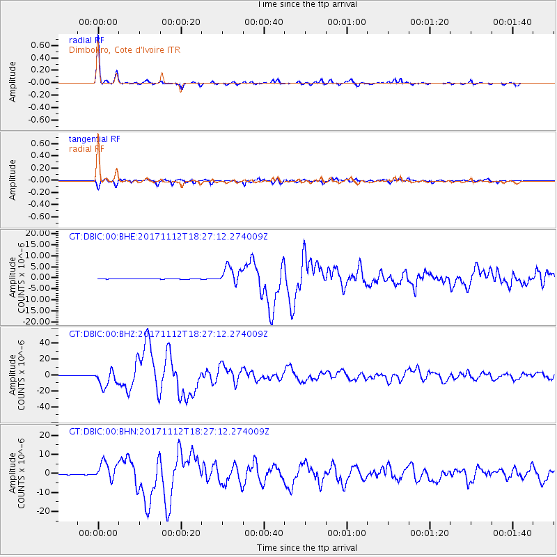
Signal To Noise
| Channel | StoN | STA | LTA |
| GT:DBIC:00:BHZ:20171112T18:27:12.274009Z | 67.17646 | 1.0697321E-5 | 1.592421E-7 |
| GT:DBIC:00:BHN:20171112T18:27:12.274009Z | 46.58052 | 4.8520856E-6 | 1.0416555E-7 |
| GT:DBIC:00:BHE:20171112T18:27:12.274009Z | 54.53226 | 4.0863424E-6 | 7.4934405E-8 |
| Arrivals |
| Ps | 4.6 SECOND |
| PpPs | 16 SECOND |
| PsPs/PpSs | 20 SECOND |


