You are here: Home > Network List > GT - Global Telemetered Seismograph Network (USAF/USGS) Stations List
> Station BOSA Boshof, South Africa > Earthquake Result Viewer
BOSA Boshof, South Africa - Earthquake Result Viewer
| Earthquake location: |
Iran-Iraq Border Region |
| Earthquake latitude/longitude: |
34.9/46.0 |
| Earthquake time(UTC): |
2017/11/12 (316) 18:18:17 GMT |
| Earthquake Depth: |
19 km |
| Earthquake Magnitude: |
7.3 Mww |
| Earthquake Catalog/Contributor: |
NEIC PDE/us |
|
| Network: |
GT Global Telemetered Seismograph Network (USAF/USGS) |
| Station: |
BOSA Boshof, South Africa |
| Lat/Lon: |
28.61 S/25.26 E |
| Elevation: |
1280 m |
|
| Distance: |
66.1 deg |
| Az: |
199.867 deg |
| Baz: |
18.523 deg |
| Ray Param: |
0.05779541 |
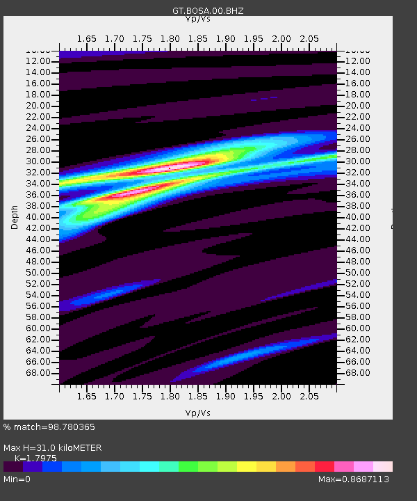
| Estimated Moho Depth: |
31.0 km |
| Estimated Crust Vp/Vs: |
1.80 |
| Assumed Crust Vp: |
6.459 km/s |
| Estimated Crust Vs: |
3.594 km/s |
| Estimated Crust Poisson's Ratio: |
0.28 |
|
| Radial Match: |
98.780365 % |
| Radial Bump: |
168 |
| Transverse Match: |
95.04909 % |
| Transverse Bump: |
400 |
| SOD ConfigId: |
13570011 |
| Insert Time: |
2019-04-29 04:28:55.198 +0000 |
| GWidth: |
2.5 |
| Max Bumps: |
400 |
| Tol: |
0.001 |
|
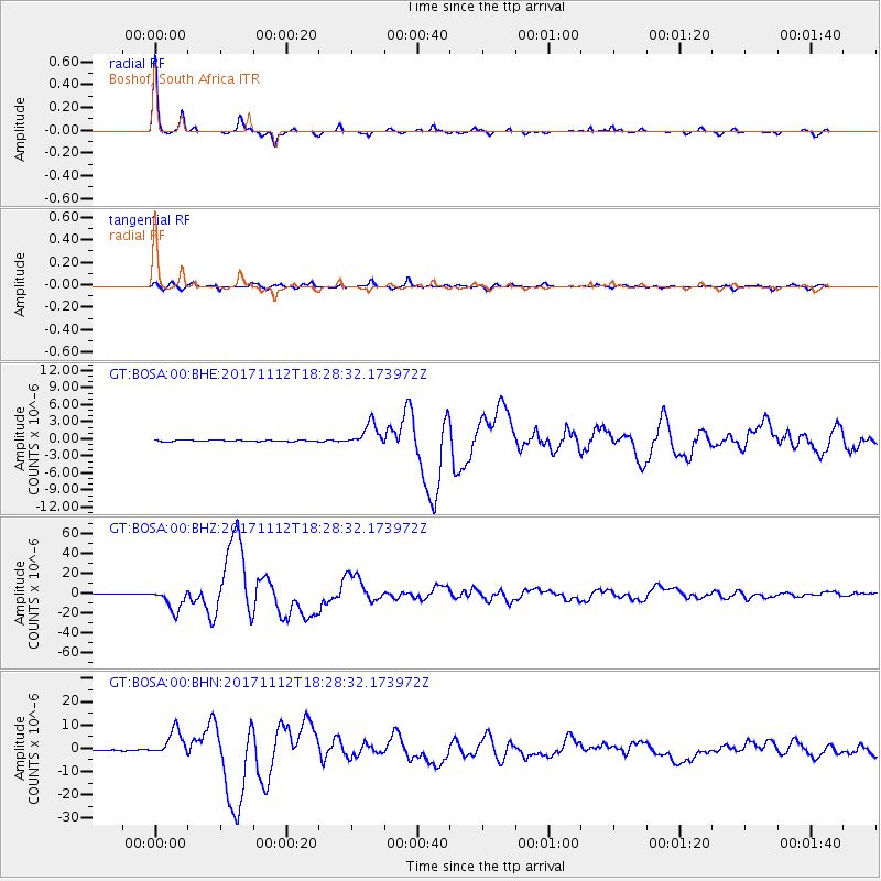
Signal To Noise
| Channel | StoN | STA | LTA |
| GT:BOSA:00:BHZ:20171112T18:28:32.173972Z | 52.76186 | 1.1161762E-5 | 2.1154982E-7 |
| GT:BOSA:00:BHN:20171112T18:28:32.173972Z | 36.92191 | 5.5470673E-6 | 1.5023782E-7 |
| GT:BOSA:00:BHE:20171112T18:28:32.173972Z | 16.433964 | 1.9840163E-6 | 1.2072658E-7 |
| Arrivals |
| Ps | 4.0 SECOND |
| PpPs | 13 SECOND |
| PsPs/PpSs | 17 SECOND |


