You are here: Home > Network List > LD - Lamont-Doherty Cooperative Seismographic Network Stations List
> Station FMMC Franklin & Marshall College/Millport Conservancy, PA > Earthquake Result Viewer
FMMC Franklin & Marshall College/Millport Conservancy, PA - Earthquake Result Viewer
| Earthquake location: |
Iran-Iraq Border Region |
| Earthquake latitude/longitude: |
34.9/46.0 |
| Earthquake time(UTC): |
2017/11/12 (316) 18:18:17 GMT |
| Earthquake Depth: |
19 km |
| Earthquake Magnitude: |
7.3 Mww |
| Earthquake Catalog/Contributor: |
NEIC PDE/us |
|
| Network: |
LD Lamont-Doherty Cooperative Seismographic Network |
| Station: |
FMMC Franklin & Marshall College/Millport Conservancy, PA |
| Lat/Lon: |
40.14 N/76.26 W |
| Elevation: |
101 m |
|
| Distance: |
88.3 deg |
| Az: |
319.541 deg |
| Baz: |
44.082 deg |
| Ray Param: |
0.042682074 |
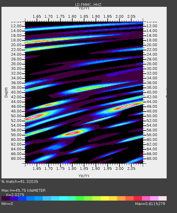
| Estimated Moho Depth: |
45.75 km |
| Estimated Crust Vp/Vs: |
2.03 |
| Assumed Crust Vp: |
6.121 km/s |
| Estimated Crust Vs: |
3.019 km/s |
| Estimated Crust Poisson's Ratio: |
0.34 |
|
| Radial Match: |
91.32035 % |
| Radial Bump: |
400 |
| Transverse Match: |
86.74508 % |
| Transverse Bump: |
400 |
| SOD ConfigId: |
13570011 |
| Insert Time: |
2019-04-29 04:29:31.178 +0000 |
| GWidth: |
2.5 |
| Max Bumps: |
400 |
| Tol: |
0.001 |
|

Signal To Noise
| Channel | StoN | STA | LTA |
| LD:FMMC: :HHZ:20171112T18:30:35.909995Z | 14.302413 | 2.8546708E-7 | 1.9959366E-8 |
| LD:FMMC: :HHN:20171112T18:30:35.909995Z | 2.485485 | 4.805074E-8 | 1.9332541E-8 |
| LD:FMMC: :HHE:20171112T18:30:35.909995Z | 6.6687384 | 9.172758E-8 | 1.3754862E-8 |
| Arrivals |
| Ps | 7.8 SECOND |
| PpPs | 22 SECOND |
| PsPs/PpSs | 30 SECOND |


