You are here: Home > Network List > LD - Lamont-Doherty Cooperative Seismographic Network Stations List
> Station MSNJ Montclair State University, NJ > Earthquake Result Viewer
MSNJ Montclair State University, NJ - Earthquake Result Viewer
| Earthquake location: |
Iran-Iraq Border Region |
| Earthquake latitude/longitude: |
34.9/46.0 |
| Earthquake time(UTC): |
2017/11/12 (316) 18:18:17 GMT |
| Earthquake Depth: |
19 km |
| Earthquake Magnitude: |
7.3 Mww |
| Earthquake Catalog/Contributor: |
NEIC PDE/us |
|
| Network: |
LD Lamont-Doherty Cooperative Seismographic Network |
| Station: |
MSNJ Montclair State University, NJ |
| Lat/Lon: |
40.88 N/74.18 W |
| Elevation: |
132 m |
|
| Distance: |
86.6 deg |
| Az: |
318.941 deg |
| Baz: |
45.399 deg |
| Ray Param: |
0.043886133 |
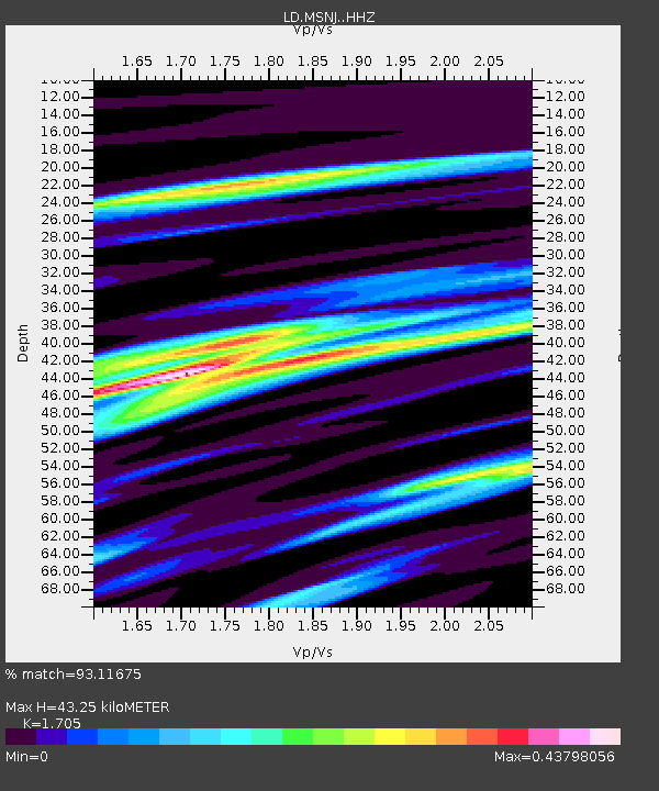
| Estimated Moho Depth: |
43.25 km |
| Estimated Crust Vp/Vs: |
1.71 |
| Assumed Crust Vp: |
6.283 km/s |
| Estimated Crust Vs: |
3.685 km/s |
| Estimated Crust Poisson's Ratio: |
0.24 |
|
| Radial Match: |
93.11675 % |
| Radial Bump: |
287 |
| Transverse Match: |
89.174774 % |
| Transverse Bump: |
400 |
| SOD ConfigId: |
13570011 |
| Insert Time: |
2019-04-29 04:29:37.368 +0000 |
| GWidth: |
2.5 |
| Max Bumps: |
400 |
| Tol: |
0.001 |
|

Signal To Noise
| Channel | StoN | STA | LTA |
| LD:MSNJ: :HHZ:20171112T18:30:28.009971Z | 16.269762 | 6.3793923E-6 | 3.9210113E-7 |
| LD:MSNJ: :HHN:20171112T18:30:28.009971Z | 3.0349445 | 1.3739083E-6 | 4.5269636E-7 |
| LD:MSNJ: :HHE:20171112T18:30:28.009971Z | 5.278343 | 2.2168297E-6 | 4.199859E-7 |
| Arrivals |
| Ps | 5.0 SECOND |
| PpPs | 18 SECOND |
| PsPs/PpSs | 23 SECOND |


