You are here: Home > Network List > LD - Lamont-Doherty Cooperative Seismographic Network Stations List
> Station ODNJ Ogdensburg, New Jersey > Earthquake Result Viewer
ODNJ Ogdensburg, New Jersey - Earthquake Result Viewer
| Earthquake location: |
Iran-Iraq Border Region |
| Earthquake latitude/longitude: |
34.9/46.0 |
| Earthquake time(UTC): |
2017/11/12 (316) 18:18:17 GMT |
| Earthquake Depth: |
19 km |
| Earthquake Magnitude: |
7.3 Mww |
| Earthquake Catalog/Contributor: |
NEIC PDE/us |
|
| Network: |
LD Lamont-Doherty Cooperative Seismographic Network |
| Station: |
ODNJ Ogdensburg, New Jersey |
| Lat/Lon: |
41.08 N/74.61 W |
| Elevation: |
187 m |
|
| Distance: |
86.7 deg |
| Az: |
319.309 deg |
| Baz: |
45.143 deg |
| Ray Param: |
0.043821424 |
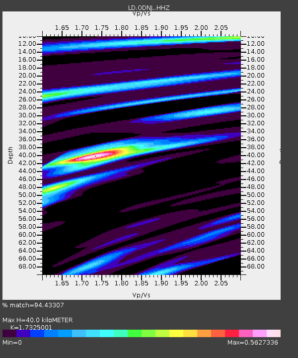
| Estimated Moho Depth: |
40.0 km |
| Estimated Crust Vp/Vs: |
1.73 |
| Assumed Crust Vp: |
6.283 km/s |
| Estimated Crust Vs: |
3.627 km/s |
| Estimated Crust Poisson's Ratio: |
0.25 |
|
| Radial Match: |
94.43307 % |
| Radial Bump: |
231 |
| Transverse Match: |
55.976067 % |
| Transverse Bump: |
400 |
| SOD ConfigId: |
13570011 |
| Insert Time: |
2019-04-29 04:29:40.363 +0000 |
| GWidth: |
2.5 |
| Max Bumps: |
400 |
| Tol: |
0.001 |
|

Signal To Noise
| Channel | StoN | STA | LTA |
| LD:ODNJ: :HHZ:20171112T18:30:28.43801Z | 11.593676 | 6.4108663E-6 | 5.529624E-7 |
| LD:ODNJ: :HHN:20171112T18:30:28.43801Z | 4.256496 | 1.5322687E-6 | 3.599836E-7 |
| LD:ODNJ: :HHE:20171112T18:30:28.43801Z | 3.554647 | 1.4292997E-6 | 4.020933E-7 |
| Arrivals |
| Ps | 4.8 SECOND |
| PpPs | 17 SECOND |
| PsPs/PpSs | 22 SECOND |


