You are here: Home > Network List > LD - Lamont-Doherty Cooperative Seismographic Network Stations List
> Station TRNY Table Rock, Ramapo, NY > Earthquake Result Viewer
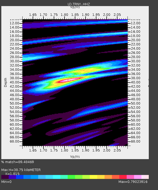
TRNY Table Rock, Ramapo, NY - Earthquake Result Viewer
| Earthquake location: |
Iran-Iraq Border Region |
| Earthquake latitude/longitude: |
34.9/46.0 |
| Earthquake time(UTC): |
2017/11/12 (316) 18:18:17 GMT |
| Earthquake Depth: |
19 km |
| Earthquake Magnitude: |
7.3 Mww |
| Earthquake Catalog/Contributor: |
NEIC PDE/us |
|
| Network: |
LD Lamont-Doherty Cooperative Seismographic Network |
| Station: |
TRNY Table Rock, Ramapo, NY |
| Lat/Lon: |
41.15 N/74.22 W |
| Elevation: |
270 m |
|
| Distance: |
86.5 deg |
| Az: |
319.15 deg |
| Baz: |
45.383 deg |
| Ray Param: |
0.044003308 |
| Estimated Moho Depth: |
38.75 km |
| Estimated Crust Vp/Vs: |
1.82 |
| Assumed Crust Vp: |
6.283 km/s |
| Estimated Crust Vs: |
3.462 km/s |
| Estimated Crust Poisson's Ratio: |
0.28 |
|
| Radial Match: |
89.48469 % |
| Radial Bump: |
279 |
| Transverse Match: |
74.16243 % |
| Transverse Bump: |
400 |
| SOD ConfigId: |
13570011 |
| Insert Time: |
2019-04-29 04:29:45.063 +0000 |
| GWidth: |
2.5 |
| Max Bumps: |
400 |
| Tol: |
0.001 |
|

Signal To Noise
| Channel | StoN | STA | LTA |
| LD:TRNY: :HHZ:20171112T18:30:27.224998Z | 18.844414 | 6.152421E-6 | 3.2648515E-7 |
| LD:TRNY: :HHN:20171112T18:30:27.224998Z | 4.9468055 | 1.6812231E-6 | 3.3986038E-7 |
| LD:TRNY: :HHE:20171112T18:30:27.224998Z | 4.798561 | 1.6584044E-6 | 3.456045E-7 |
| Arrivals |
| Ps | 5.1 SECOND |
| PpPs | 17 SECOND |
| PsPs/PpSs | 22 SECOND |


