You are here: Home > Network List > N4 - Central and EAstern US Network Stations List
> Station E46A Sault Ste Marie, MI, USA > Earthquake Result Viewer
E46A Sault Ste Marie, MI, USA - Earthquake Result Viewer
| Earthquake location: |
Iran-Iraq Border Region |
| Earthquake latitude/longitude: |
34.9/46.0 |
| Earthquake time(UTC): |
2017/11/12 (316) 18:18:17 GMT |
| Earthquake Depth: |
19 km |
| Earthquake Magnitude: |
7.3 Mww |
| Earthquake Catalog/Contributor: |
NEIC PDE/us |
|
| Network: |
N4 Central and EAstern US Network |
| Station: |
E46A Sault Ste Marie, MI, USA |
| Lat/Lon: |
46.37 N/84.31 W |
| Elevation: |
269 m |
|
| Distance: |
87.5 deg |
| Az: |
328.068 deg |
| Baz: |
38.886 deg |
| Ray Param: |
0.04324757 |
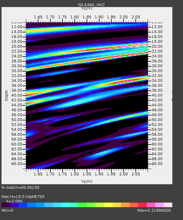
| Estimated Moho Depth: |
19.0 km |
| Estimated Crust Vp/Vs: |
2.10 |
| Assumed Crust Vp: |
6.467 km/s |
| Estimated Crust Vs: |
3.087 km/s |
| Estimated Crust Poisson's Ratio: |
0.35 |
|
| Radial Match: |
85.88188 % |
| Radial Bump: |
246 |
| Transverse Match: |
52.262566 % |
| Transverse Bump: |
301 |
| SOD ConfigId: |
13570011 |
| Insert Time: |
2019-04-29 04:30:13.865 +0000 |
| GWidth: |
2.5 |
| Max Bumps: |
400 |
| Tol: |
0.001 |
|

Signal To Noise
| Channel | StoN | STA | LTA |
| N4:E46A: :HHZ:20171112T18:30:32.27999Z | 8.545758 | 7.099757E-6 | 8.307931E-7 |
| N4:E46A: :HHN:20171112T18:30:32.27999Z | 2.6624756 | 1.9041659E-6 | 7.1518616E-7 |
| N4:E46A: :HHE:20171112T18:30:32.27999Z | 1.5952748 | 1.0956562E-6 | 6.868135E-7 |
| Arrivals |
| Ps | 3.3 SECOND |
| PpPs | 8.9 SECOND |
| PsPs/PpSs | 12 SECOND |


