You are here: Home > Network List > N4 - Central and EAstern US Network Stations List
> Station F62A Pittston Farm, Pittston Academy Grant, ME, USA > Earthquake Result Viewer
F62A Pittston Farm, Pittston Academy Grant, ME, USA - Earthquake Result Viewer
| Earthquake location: |
Iran-Iraq Border Region |
| Earthquake latitude/longitude: |
34.9/46.0 |
| Earthquake time(UTC): |
2017/11/12 (316) 18:18:17 GMT |
| Earthquake Depth: |
19 km |
| Earthquake Magnitude: |
7.3 Mww |
| Earthquake Catalog/Contributor: |
NEIC PDE/us |
|
| Network: |
N4 Central and EAstern US Network |
| Station: |
F62A Pittston Farm, Pittston Academy Grant, ME, USA |
| Lat/Lon: |
45.90 N/69.97 W |
| Elevation: |
331 m |
|
| Distance: |
81.0 deg |
| Az: |
320.509 deg |
| Baz: |
48.457 deg |
| Ray Param: |
0.047892597 |
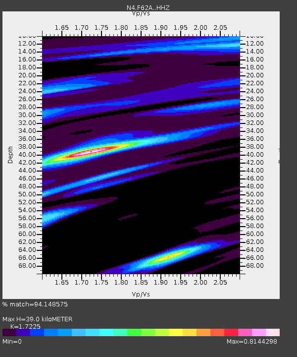
| Estimated Moho Depth: |
39.0 km |
| Estimated Crust Vp/Vs: |
1.72 |
| Assumed Crust Vp: |
6.419 km/s |
| Estimated Crust Vs: |
3.727 km/s |
| Estimated Crust Poisson's Ratio: |
0.25 |
|
| Radial Match: |
94.148575 % |
| Radial Bump: |
317 |
| Transverse Match: |
80.26236 % |
| Transverse Bump: |
400 |
| SOD ConfigId: |
13570011 |
| Insert Time: |
2019-04-29 04:30:18.575 +0000 |
| GWidth: |
2.5 |
| Max Bumps: |
400 |
| Tol: |
0.001 |
|

Signal To Noise
| Channel | StoN | STA | LTA |
| N4:F62A: :HHZ:20171112T18:29:59.159995Z | 15.331035 | 8.0245145E-6 | 5.2341636E-7 |
| N4:F62A: :HHN:20171112T18:29:59.159995Z | 3.7817957 | 2.136972E-6 | 5.6506804E-7 |
| N4:F62A: :HHE:20171112T18:29:59.159995Z | 3.5282016 | 2.3345403E-6 | 6.6167996E-7 |
| Arrivals |
| Ps | 4.5 SECOND |
| PpPs | 16 SECOND |
| PsPs/PpSs | 21 SECOND |


