You are here: Home > Network List > N4 - Central and EAstern US Network Stations List
> Station N58A Sunbury, PA, USA > Earthquake Result Viewer
N58A Sunbury, PA, USA - Earthquake Result Viewer
| Earthquake location: |
Iran-Iraq Border Region |
| Earthquake latitude/longitude: |
34.9/46.0 |
| Earthquake time(UTC): |
2017/11/12 (316) 18:18:17 GMT |
| Earthquake Depth: |
19 km |
| Earthquake Magnitude: |
7.3 Mww |
| Earthquake Catalog/Contributor: |
NEIC PDE/us |
|
| Network: |
N4 Central and EAstern US Network |
| Station: |
N58A Sunbury, PA, USA |
| Lat/Lon: |
40.84 N/76.72 W |
| Elevation: |
200 m |
|
| Distance: |
88.0 deg |
| Az: |
320.28 deg |
| Baz: |
43.809 deg |
| Ray Param: |
0.042877395 |
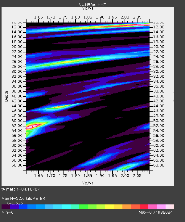
| Estimated Moho Depth: |
52.0 km |
| Estimated Crust Vp/Vs: |
1.62 |
| Assumed Crust Vp: |
6.121 km/s |
| Estimated Crust Vs: |
3.766 km/s |
| Estimated Crust Poisson's Ratio: |
0.20 |
|
| Radial Match: |
84.18707 % |
| Radial Bump: |
251 |
| Transverse Match: |
80.48447 % |
| Transverse Bump: |
306 |
| SOD ConfigId: |
13570011 |
| Insert Time: |
2019-04-29 04:30:58.423 +0000 |
| GWidth: |
2.5 |
| Max Bumps: |
400 |
| Tol: |
0.001 |
|

Signal To Noise
| Channel | StoN | STA | LTA |
| N4:N58A: :HHZ:20171112T18:30:34.659995Z | 9.086302 | 6.1702153E-6 | 6.790679E-7 |
| N4:N58A: :HHN:20171112T18:30:34.659995Z | 4.2370753 | 1.8589176E-6 | 4.3872657E-7 |
| N4:N58A: :HHE:20171112T18:30:34.659995Z | 2.8792791 | 1.2716623E-6 | 4.4165995E-7 |
| Arrivals |
| Ps | 5.4 SECOND |
| PpPs | 22 SECOND |
| PsPs/PpSs | 27 SECOND |


