You are here: Home > Network List > TA - USArray Transportable Network (new EarthScope stations) Stations List
> Station D18A Linhart Farms, Moccasin, MT, USA > Earthquake Result Viewer
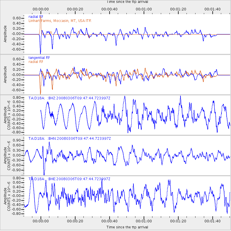
D18A Linhart Farms, Moccasin, MT, USA - Earthquake Result Viewer
*The percent match for this event was below the threshold and hence no stack was calculated.
| Earthquake location: |
Kamchatka Peninsula, Russia |
| Earthquake latitude/longitude: |
51.5/156.5 |
| Earthquake time(UTC): |
2008/03/06 (066) 09:38:43 GMT |
| Earthquake Depth: |
134 km |
| Earthquake Magnitude: |
5.6 MB, 5.5 MW, 5.5 MW |
| Earthquake Catalog/Contributor: |
WHDF/NEIC |
|
| Network: |
TA USArray Transportable Network (new EarthScope stations) |
| Station: |
D18A Linhart Farms, Moccasin, MT, USA |
| Lat/Lon: |
47.20 N/109.80 W |
| Elevation: |
1202 m |
|
| Distance: |
57.0 deg |
| Az: |
54.198 deg |
| Baz: |
312.008 deg |
| Ray Param: |
$rayparam |
*The percent match for this event was below the threshold and hence was not used in the summary stack. |
|
| Radial Match: |
55.541496 % |
| Radial Bump: |
400 |
| Transverse Match: |
47.18811 % |
| Transverse Bump: |
400 |
| SOD ConfigId: |
2504 |
| Insert Time: |
2010-03-06 06:15:59.326 +0000 |
| GWidth: |
2.5 |
| Max Bumps: |
400 |
| Tol: |
0.001 |
|
Signal To Noise
| Channel | StoN | STA | LTA |
| TA:D18A: :BHN:20080306T09:47:44.723997Z | 2.115945 | 4.663004E-7 | 2.2037453E-7 |
| TA:D18A: :BHE:20080306T09:47:44.723997Z | 0.73593175 | 2.7559312E-7 | 3.744819E-7 |
| TA:D18A: :BHZ:20080306T09:47:44.723997Z | 1.011547 | 3.7550254E-7 | 3.7121612E-7 |
| Arrivals |
| Ps | |
| PpPs | |
| PsPs/PpSs | |


