You are here: Home > Network List > NR - NARS Array Stations List
> Station NE203 Kole > Earthquake Result Viewer
NE203 Kole - Earthquake Result Viewer
| Earthquake location: |
Iran-Iraq Border Region |
| Earthquake latitude/longitude: |
34.9/46.0 |
| Earthquake time(UTC): |
2017/11/12 (316) 18:18:17 GMT |
| Earthquake Depth: |
19 km |
| Earthquake Magnitude: |
7.3 Mww |
| Earthquake Catalog/Contributor: |
NEIC PDE/us |
|
| Network: |
NR NARS Array |
| Station: |
NE203 Kole |
| Lat/Lon: |
22.99 S/20.20 E |
| Elevation: |
1313 m |
|
| Distance: |
62.6 deg |
| Az: |
206.825 deg |
| Baz: |
23.735 deg |
| Ray Param: |
0.06012739 |
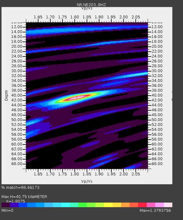
| Estimated Moho Depth: |
40.75 km |
| Estimated Crust Vp/Vs: |
1.81 |
| Assumed Crust Vp: |
6.34 km/s |
| Estimated Crust Vs: |
3.508 km/s |
| Estimated Crust Poisson's Ratio: |
0.28 |
|
| Radial Match: |
98.46173 % |
| Radial Bump: |
284 |
| Transverse Match: |
95.32461 % |
| Transverse Bump: |
400 |
| SOD ConfigId: |
13570011 |
| Insert Time: |
2019-04-29 04:31:53.744 +0000 |
| GWidth: |
2.5 |
| Max Bumps: |
400 |
| Tol: |
0.001 |
|

Signal To Noise
| Channel | StoN | STA | LTA |
| NR:NE203: :BHZ:20171112T18:28:08.779014Z | 65.79833 | 1.4481074E-5 | 2.2008268E-7 |
| NR:NE203: :BHN:20171112T18:28:08.779014Z | 24.520359 | 5.3237973E-6 | 2.1711742E-7 |
| NR:NE203: :BHE:20171112T18:28:08.779014Z | 24.026764 | 4.137046E-6 | 1.7218488E-7 |
| Arrivals |
| Ps | 5.4 SECOND |
| PpPs | 17 SECOND |
| PsPs/PpSs | 23 SECOND |


