You are here: Home > Network List > NR - NARS Array Stations List
> Station NE205 Selinda > Earthquake Result Viewer
NE205 Selinda - Earthquake Result Viewer
| Earthquake location: |
Iran-Iraq Border Region |
| Earthquake latitude/longitude: |
34.9/46.0 |
| Earthquake time(UTC): |
2017/11/12 (316) 18:18:17 GMT |
| Earthquake Depth: |
19 km |
| Earthquake Magnitude: |
7.3 Mww |
| Earthquake Catalog/Contributor: |
NEIC PDE/us |
|
| Network: |
NR NARS Array |
| Station: |
NE205 Selinda |
| Lat/Lon: |
18.62 S/23.50 E |
| Elevation: |
961 m |
|
| Distance: |
57.3 deg |
| Az: |
205.48 deg |
| Baz: |
21.892 deg |
| Ray Param: |
0.0635265 |
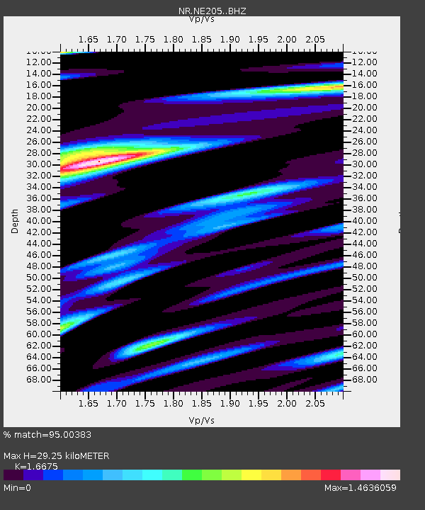
| Estimated Moho Depth: |
29.25 km |
| Estimated Crust Vp/Vs: |
1.67 |
| Assumed Crust Vp: |
6.516 km/s |
| Estimated Crust Vs: |
3.908 km/s |
| Estimated Crust Poisson's Ratio: |
0.22 |
|
| Radial Match: |
95.00383 % |
| Radial Bump: |
400 |
| Transverse Match: |
87.78406 % |
| Transverse Bump: |
400 |
| SOD ConfigId: |
13570011 |
| Insert Time: |
2019-04-29 04:31:54.685 +0000 |
| GWidth: |
2.5 |
| Max Bumps: |
400 |
| Tol: |
0.001 |
|

Signal To Noise
| Channel | StoN | STA | LTA |
| NR:NE205: :BHZ:20171112T18:27:33.104026Z | 73.41964 | 1.5793148E-5 | 2.1510795E-7 |
| NR:NE205: :BHN:20171112T18:27:33.104026Z | 25.30891 | 7.3021065E-6 | 2.885192E-7 |
| NR:NE205: :BHE:20171112T18:27:33.104026Z | 18.848646 | 6.2896465E-6 | 3.336922E-7 |
| Arrivals |
| Ps | 3.2 SECOND |
| PpPs | 11 SECOND |
| PsPs/PpSs | 15 SECOND |


