You are here: Home > Network List > NR - NARS Array Stations List
> Station NE217 Borolong > Earthquake Result Viewer
NE217 Borolong - Earthquake Result Viewer
| Earthquake location: |
Iran-Iraq Border Region |
| Earthquake latitude/longitude: |
34.9/46.0 |
| Earthquake time(UTC): |
2017/11/12 (316) 18:18:17 GMT |
| Earthquake Depth: |
19 km |
| Earthquake Magnitude: |
7.3 Mww |
| Earthquake Catalog/Contributor: |
NEIC PDE/us |
|
| Network: |
NR NARS Array |
| Station: |
NE217 Borolong |
| Lat/Lon: |
21.10 S/27.33 E |
| Elevation: |
1047 m |
|
| Distance: |
58.4 deg |
| Az: |
200.483 deg |
| Baz: |
17.94 deg |
| Ray Param: |
0.062823236 |
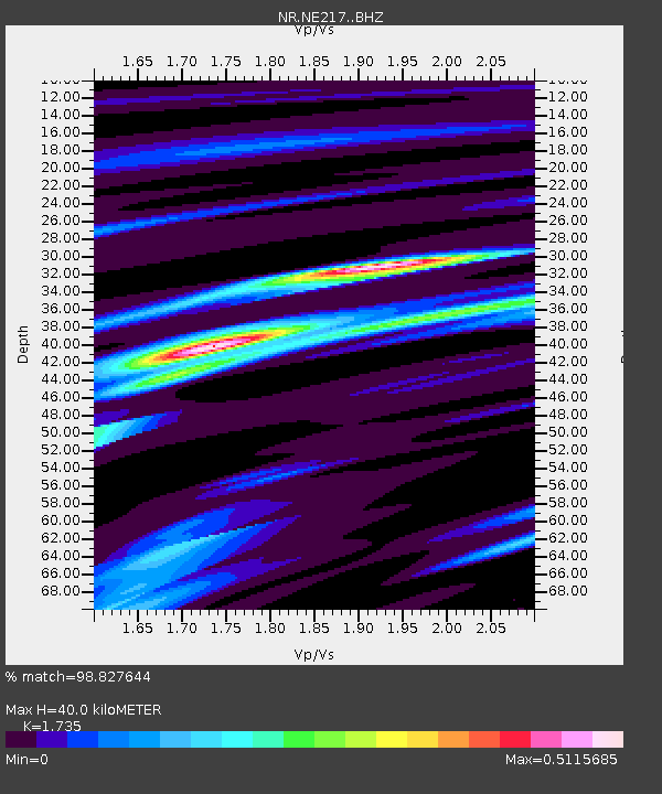
| Estimated Moho Depth: |
40.0 km |
| Estimated Crust Vp/Vs: |
1.74 |
| Assumed Crust Vp: |
6.459 km/s |
| Estimated Crust Vs: |
3.723 km/s |
| Estimated Crust Poisson's Ratio: |
0.25 |
|
| Radial Match: |
98.827644 % |
| Radial Bump: |
190 |
| Transverse Match: |
91.90037 % |
| Transverse Bump: |
400 |
| SOD ConfigId: |
13570011 |
| Insert Time: |
2019-04-29 04:31:59.265 +0000 |
| GWidth: |
2.5 |
| Max Bumps: |
400 |
| Tol: |
0.001 |
|

Signal To Noise
| Channel | StoN | STA | LTA |
| NR:NE217: :BHZ:20171112T18:27:40.735984Z | 69.61833 | 1.553012E-5 | 2.2307518E-7 |
| NR:NE217: :BHN:20171112T18:27:40.735984Z | 40.32617 | 7.586048E-6 | 1.8811724E-7 |
| NR:NE217: :BHE:20171112T18:27:40.735984Z | 18.746246 | 2.6064454E-6 | 1.3903825E-7 |
| Arrivals |
| Ps | 4.8 SECOND |
| PpPs | 16 SECOND |
| PsPs/PpSs | 21 SECOND |


