You are here: Home > Network List > ON - RSIS-Rede Sismografica do Sul e Sudeste Observatorio Nacional, Brazil Stations List
> Station NAN01 "OBSN: [NAN01] Nanuque, MG" > Earthquake Result Viewer
NAN01 "OBSN: [NAN01] Nanuque, MG" - Earthquake Result Viewer
| Earthquake location: |
Iran-Iraq Border Region |
| Earthquake latitude/longitude: |
34.9/46.0 |
| Earthquake time(UTC): |
2017/11/12 (316) 18:18:17 GMT |
| Earthquake Depth: |
19 km |
| Earthquake Magnitude: |
7.3 Mww |
| Earthquake Catalog/Contributor: |
NEIC PDE/us |
|
| Network: |
ON RSIS-Rede Sismografica do Sul e Sudeste Observatorio Nacional, Brazil |
| Station: |
NAN01 "OBSN: [NAN01] Nanuque, MG" |
| Lat/Lon: |
17.84 S/40.13 W |
| Elevation: |
206 m |
|
| Distance: |
96.9 deg |
| Az: |
253.173 deg |
| Baz: |
55.684 deg |
| Ray Param: |
0.040372945 |
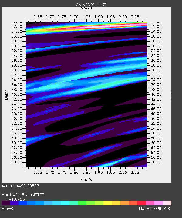
| Estimated Moho Depth: |
11.5 km |
| Estimated Crust Vp/Vs: |
1.94 |
| Assumed Crust Vp: |
6.459 km/s |
| Estimated Crust Vs: |
3.325 km/s |
| Estimated Crust Poisson's Ratio: |
0.32 |
|
| Radial Match: |
93.38527 % |
| Radial Bump: |
400 |
| Transverse Match: |
75.25803 % |
| Transverse Bump: |
400 |
| SOD ConfigId: |
13570011 |
| Insert Time: |
2019-04-29 04:32:12.102 +0000 |
| GWidth: |
2.5 |
| Max Bumps: |
400 |
| Tol: |
0.001 |
|

Signal To Noise
| Channel | StoN | STA | LTA |
| ON:NAN01: :HHZ:20171112T18:31:15.417991Z | 4.1004925 | 9.1547383E-7 | 2.2325948E-7 |
| ON:NAN01: :HH1:20171112T18:31:15.417991Z | 2.66332 | 4.4930556E-7 | 1.687013E-7 |
| ON:NAN01: :HH2:20171112T18:31:15.417991Z | 1.3008053 | 2.8331038E-7 | 2.1779614E-7 |
| Arrivals |
| Ps | 1.7 SECOND |
| PpPs | 5.1 SECOND |
| PsPs/PpSs | 6.9 SECOND |


