You are here: Home > Network List > PE - Penn State Network Stations List
> Station PSUB Penn State - Brandywine Campus > Earthquake Result Viewer
PSUB Penn State - Brandywine Campus - Earthquake Result Viewer
| Earthquake location: |
Iran-Iraq Border Region |
| Earthquake latitude/longitude: |
34.9/46.0 |
| Earthquake time(UTC): |
2017/11/12 (316) 18:18:17 GMT |
| Earthquake Depth: |
19 km |
| Earthquake Magnitude: |
7.3 Mww |
| Earthquake Catalog/Contributor: |
NEIC PDE/us |
|
| Network: |
PE Penn State Network |
| Station: |
PSUB Penn State - Brandywine Campus |
| Lat/Lon: |
39.93 N/75.45 W |
| Elevation: |
110 m |
|
| Distance: |
88.0 deg |
| Az: |
318.951 deg |
| Baz: |
44.58 deg |
| Ray Param: |
0.042892244 |
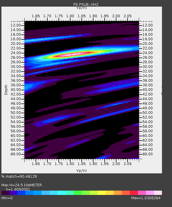
| Estimated Moho Depth: |
24.5 km |
| Estimated Crust Vp/Vs: |
1.81 |
| Assumed Crust Vp: |
6.287 km/s |
| Estimated Crust Vs: |
3.483 km/s |
| Estimated Crust Poisson's Ratio: |
0.28 |
|
| Radial Match: |
90.46129 % |
| Radial Bump: |
381 |
| Transverse Match: |
72.17848 % |
| Transverse Bump: |
399 |
| SOD ConfigId: |
13570011 |
| Insert Time: |
2019-04-29 04:32:29.572 +0000 |
| GWidth: |
2.5 |
| Max Bumps: |
400 |
| Tol: |
0.001 |
|

Signal To Noise
| Channel | StoN | STA | LTA |
| PE:PSUB: :HHZ:20171112T18:30:34.55001Z | 15.956872 | 7.728764E-6 | 4.843533E-7 |
| PE:PSUB: :HHN:20171112T18:30:34.55001Z | 3.8917456 | 2.2412128E-6 | 5.758888E-7 |
| PE:PSUB: :HHE:20171112T18:30:34.55001Z | 2.4145827 | 1.7031026E-6 | 7.053403E-7 |
| Arrivals |
| Ps | 3.2 SECOND |
| PpPs | 11 SECOND |
| PsPs/PpSs | 14 SECOND |


