You are here: Home > Network List > TA - USArray Transportable Network (new EarthScope stations) Stations List
> Station M18A Lyman, WY, USA > Earthquake Result Viewer
M18A Lyman, WY, USA - Earthquake Result Viewer
| Earthquake location: |
Loyalty Islands |
| Earthquake latitude/longitude: |
-20.1/168.9 |
| Earthquake time(UTC): |
2008/04/09 (100) 12:46:12 GMT |
| Earthquake Depth: |
33 km |
| Earthquake Magnitude: |
6.3 MB, 7.3 MS, 7.3 MW, 7.3 MW |
| Earthquake Catalog/Contributor: |
WHDF/NEIC |
|
| Network: |
TA USArray Transportable Network (new EarthScope stations) |
| Station: |
M18A Lyman, WY, USA |
| Lat/Lon: |
41.43 N/110.07 W |
| Elevation: |
2103 m |
|
| Distance: |
96.6 deg |
| Az: |
48.397 deg |
| Baz: |
249.182 deg |
| Ray Param: |
0.04045323 |
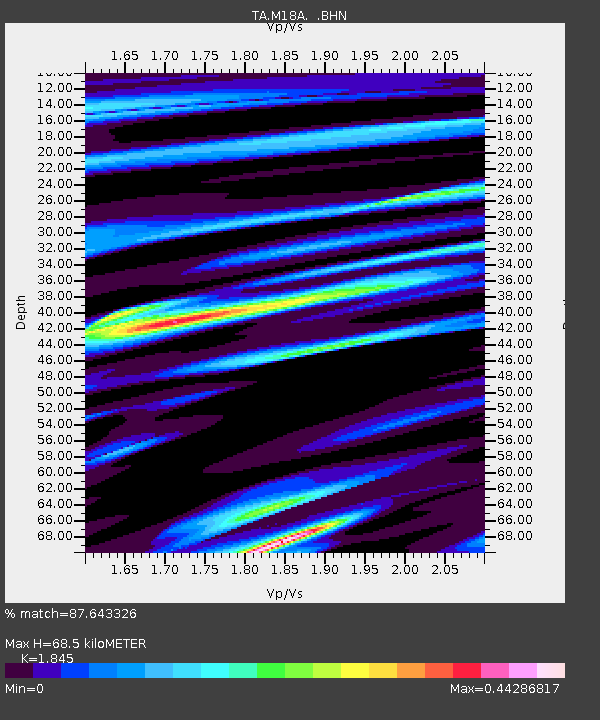
| Estimated Moho Depth: |
68.5 km |
| Estimated Crust Vp/Vs: |
1.85 |
| Assumed Crust Vp: |
6.155 km/s |
| Estimated Crust Vs: |
3.336 km/s |
| Estimated Crust Poisson's Ratio: |
0.29 |
|
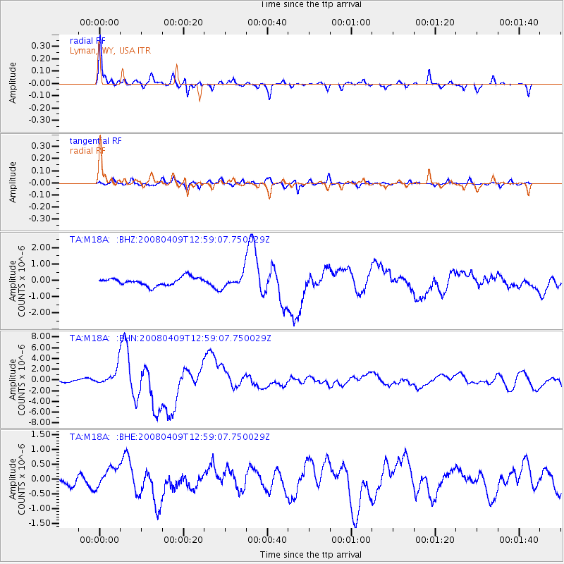
| Radial Match: |
87.643326 % |
| Radial Bump: |
345 |
| Transverse Match: |
78.635506 % |
| Transverse Bump: |
400 |
| SOD ConfigId: |
2504 |
| Insert Time: |
2010-03-06 06:16:38.962 +0000 |
| GWidth: |
2.5 |
| Max Bumps: |
400 |
| Tol: |
0.001 |
|
Signal To Noise
| Channel | StoN | STA | LTA |
| TA:M18A: :BHN:20080409T12:59:07.750029Z | 6.334071 | 1.7931234E-6 | 2.8309177E-7 |
| TA:M18A: :BHE:20080409T12:59:07.750029Z | 1.8418756 | 3.6771306E-7 | 1.9964054E-7 |
| TA:M18A: :BHZ:20080409T12:59:07.750029Z | 1.7399683 | 4.199658E-7 | 2.4136403E-7 |
| Arrivals |
| Ps | 9.6 SECOND |
| PpPs | 31 SECOND |
| PsPs/PpSs | 41 SECOND |


