You are here: Home > Network List > RV - Regional Alberta Seismic Observatory for Earthquake Studies Network Stations List
> Station STPRA Salt Prairie Lookout Tower, AB > Earthquake Result Viewer
STPRA Salt Prairie Lookout Tower, AB - Earthquake Result Viewer
| Earthquake location: |
Iran-Iraq Border Region |
| Earthquake latitude/longitude: |
34.9/46.0 |
| Earthquake time(UTC): |
2017/11/12 (316) 18:18:17 GMT |
| Earthquake Depth: |
19 km |
| Earthquake Magnitude: |
7.3 Mww |
| Earthquake Catalog/Contributor: |
NEIC PDE/us |
|
| Network: |
RV Regional Alberta Seismic Observatory for Earthquake Studies Network |
| Station: |
STPRA Salt Prairie Lookout Tower, AB |
| Lat/Lon: |
55.66 N/115.83 W |
| Elevation: |
761 m |
|
| Distance: |
88.5 deg |
| Az: |
349.795 deg |
| Baz: |
14.889 deg |
| Ray Param: |
0.04255696 |
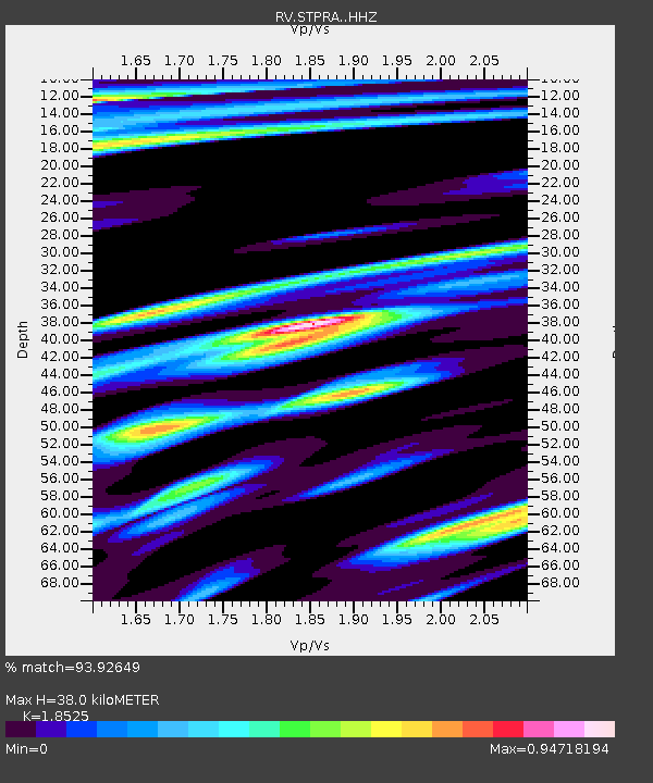
| Estimated Moho Depth: |
38.0 km |
| Estimated Crust Vp/Vs: |
1.85 |
| Assumed Crust Vp: |
6.483 km/s |
| Estimated Crust Vs: |
3.499 km/s |
| Estimated Crust Poisson's Ratio: |
0.29 |
|
| Radial Match: |
93.92649 % |
| Radial Bump: |
357 |
| Transverse Match: |
84.21896 % |
| Transverse Bump: |
393 |
| SOD ConfigId: |
13570011 |
| Insert Time: |
2019-04-29 04:33:00.728 +0000 |
| GWidth: |
2.5 |
| Max Bumps: |
400 |
| Tol: |
0.001 |
|

Signal To Noise
| Channel | StoN | STA | LTA |
| RV:STPRA: :HHZ:20171112T18:30:36.709983Z | 30.870228 | 1.4700459E-5 | 4.7620185E-7 |
| RV:STPRA: :HHN:20171112T18:30:36.709983Z | 5.0517726 | 5.8095225E-6 | 1.1499968E-6 |
| RV:STPRA: :HHE:20171112T18:30:36.709983Z | 2.0031912 | 2.7076474E-6 | 1.351667E-6 |
| Arrivals |
| Ps | 5.1 SECOND |
| PpPs | 16 SECOND |
| PsPs/PpSs | 21 SECOND |


