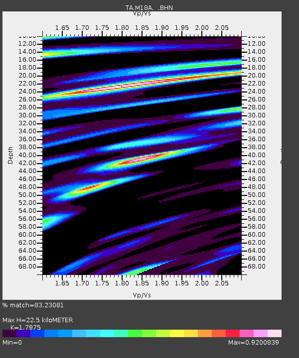
M18A Lyman, WY, USA - Earthquake Result Viewer
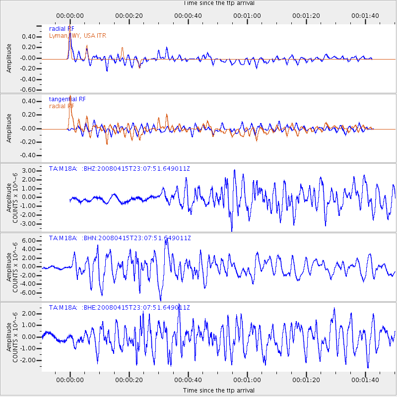
Earthquake location: Andreanof Islands, Aleutian Is.
Earthquake latitude/longitude: 51.9/-179.4
Earthquake time(UTC): 2008/04/15 (106) 22:59:51 GMT
Earthquake Depth: 10 km
Earthquake Magnitude: 6.1 MB, 6.4 MS, 6.4 MW, 6.4 MW
Earthquake Catalog/Contributor: WHDF/NEIC
Network: TA USArray Transportable Network (new EarthScope stations)
Station: M18A Lyman, WY, USA
Lat/Lon: 41.43 N/110.07 W
Elevation: 2103 m
Distance: 47.0 deg
Az: 74.11 deg
Baz: 307.508 deg
Ray Param: 0.07028164
Estimated Moho Depth: 22.5 km
Estimated Crust Vp/Vs: 1.80
Assumed Crust Vp: 6.155 km/s
Estimated Crust Vs: 3.424 km/s
Estimated Crust Poisson's Ratio: 0.28
Radial Match: 83.23081 %
Radial Bump: 400
Transverse Match: 72.38181 %
Transverse Bump: 400
SOD ConfigId: 2504
Insert Time: 2010-03-06 06:16:42.436 +0000
GWidth: 2.5
Max Bumps: 400
Tol: 0.001

Signal To Noise

ChannelStoNSTALTA
TA:M18A: :BHN:20080415T23:07:51.649011Z5.5089521.4135634E-62.5659386E-7
TA:M18A: :BHE:20080415T23:07:51.649011Z1.64461484.816774E-72.9288157E-7
TA:M18A: :BHZ:20080415T23:07:51.649011Z2.37059145.9743917E-72.5202115E-7
Arrivals
Ps3.1 SECOND
PpPs9.7 SECOND
PsPs/PpSs13 SECOND