You are here: Home > Network List > TA - USArray Transportable Network (new EarthScope stations) Stations List
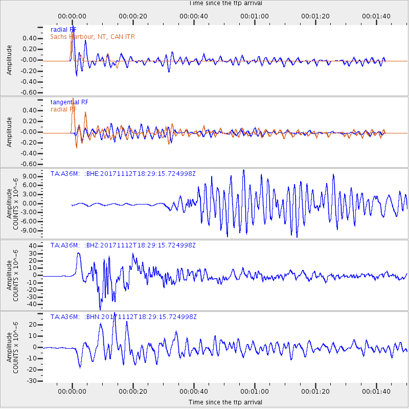
> Station A36M Sachs Harbour, NT, CAN > Earthquake Result Viewer
A36M Sachs Harbour, NT, CAN - Earthquake Result Viewer
| Earthquake location: |
Iran-Iraq Border Region |
| Earthquake latitude/longitude: |
34.9/46.0 |
| Earthquake time(UTC): |
2017/11/12 (316) 18:18:17 GMT |
| Earthquake Depth: |
19 km |
| Earthquake Magnitude: |
7.3 Mww |
| Earthquake Catalog/Contributor: |
NEIC PDE/us |
|
| Network: |
TA USArray Transportable Network (new EarthScope stations) |
| Station: |
A36M Sachs Harbour, NT, CAN |
| Lat/Lon: |
71.99 N/125.25 W |
| Elevation: |
32 m |
|
| Distance: |
73.2 deg |
| Az: |
357.152 deg |
| Baz: |
7.543 deg |
| Ray Param: |
0.0531292 |
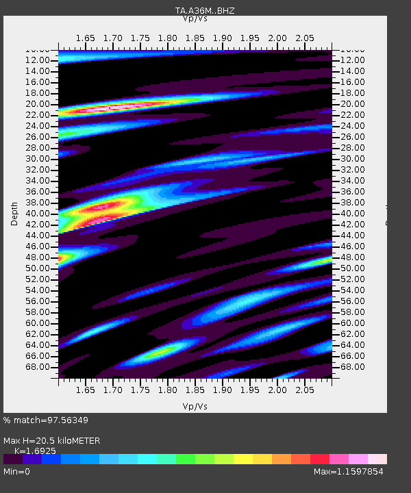
| Estimated Moho Depth: |
20.5 km |
| Estimated Crust Vp/Vs: |
1.69 |
| Assumed Crust Vp: |
6.24 km/s |
| Estimated Crust Vs: |
3.687 km/s |
| Estimated Crust Poisson's Ratio: |
0.23 |
|
| Radial Match: |
97.56349 % |
| Radial Bump: |
400 |
| Transverse Match: |
94.316414 % |
| Transverse Bump: |
400 |
| SOD ConfigId: |
13570011 |
| Insert Time: |
2019-04-29 04:33:10.900 +0000 |
| GWidth: |
2.5 |
| Max Bumps: |
400 |
| Tol: |
0.001 |
|
Signal To Noise
| Channel | StoN | STA | LTA |
| TA:A36M: :BHZ:20171112T18:29:15.724998Z | 85.789276 | 1.4749392E-5 | 1.7192582E-7 |
| TA:A36M: :BHN:20171112T18:29:15.724998Z | 23.150055 | 7.0613687E-6 | 3.05026E-7 |
| TA:A36M: :BHE:20171112T18:29:15.724998Z | 3.8688765 | 9.91063E-7 | 2.56163E-7 |
| Arrivals |
| Ps | 2.4 SECOND |
| PpPs | 8.6 SECOND |
| PsPs/PpSs | 11 SECOND |


