You are here: Home > Network List > TA - USArray Transportable Network (new EarthScope stations) Stations List
> Station M18A Lyman, WY, USA > Earthquake Result Viewer
M18A Lyman, WY, USA - Earthquake Result Viewer
| Earthquake location: |
Solomon Islands |
| Earthquake latitude/longitude: |
-10.5/161.3 |
| Earthquake time(UTC): |
2008/06/03 (155) 16:20:50 GMT |
| Earthquake Depth: |
84 km |
| Earthquake Magnitude: |
6.2 MB, 6.2 MW, 6.2 MW |
| Earthquake Catalog/Contributor: |
WHDF/NEIC |
|
| Network: |
TA USArray Transportable Network (new EarthScope stations) |
| Station: |
M18A Lyman, WY, USA |
| Lat/Lon: |
41.43 N/110.07 W |
| Elevation: |
2103 m |
|
| Distance: |
95.9 deg |
| Az: |
49.09 deg |
| Baz: |
261.244 deg |
| Ray Param: |
0.040612545 |
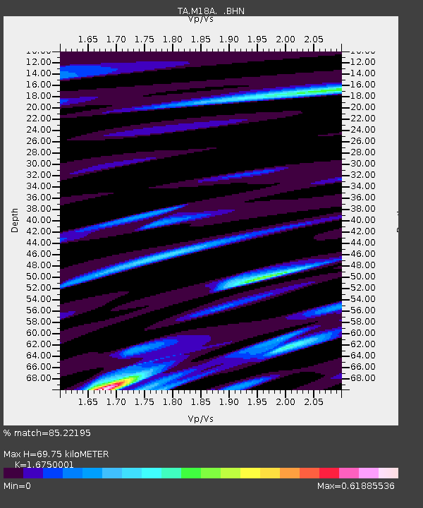
| Estimated Moho Depth: |
69.75 km |
| Estimated Crust Vp/Vs: |
1.68 |
| Assumed Crust Vp: |
6.155 km/s |
| Estimated Crust Vs: |
3.675 km/s |
| Estimated Crust Poisson's Ratio: |
0.22 |
|
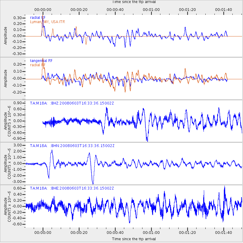
| Radial Match: |
85.22195 % |
| Radial Bump: |
400 |
| Transverse Match: |
72.2441 % |
| Transverse Bump: |
400 |
| SOD ConfigId: |
2504 |
| Insert Time: |
2010-03-06 06:16:48.631 +0000 |
| GWidth: |
2.5 |
| Max Bumps: |
400 |
| Tol: |
0.001 |
|
Signal To Noise
| Channel | StoN | STA | LTA |
| TA:M18A: :BHN:20080603T16:33:36.15002Z | 14.456961 | 1.0392988E-6 | 7.188916E-8 |
| TA:M18A: :BHE:20080603T16:33:36.15002Z | 1.1062814 | 9.655701E-8 | 8.728069E-8 |
| TA:M18A: :BHZ:20080603T16:33:36.15002Z | 2.838452 | 2.5125647E-7 | 8.851883E-8 |
| Arrivals |
| Ps | 7.8 SECOND |
| PpPs | 30 SECOND |
| PsPs/PpSs | 38 SECOND |


