You are here: Home > Network List > TA - USArray Transportable Network (new EarthScope stations) Stations List
> Station B22K Teshekpuk Lake, AK, USA > Earthquake Result Viewer
B22K Teshekpuk Lake, AK, USA - Earthquake Result Viewer
| Earthquake location: |
Iran-Iraq Border Region |
| Earthquake latitude/longitude: |
34.9/46.0 |
| Earthquake time(UTC): |
2017/11/12 (316) 18:18:17 GMT |
| Earthquake Depth: |
19 km |
| Earthquake Magnitude: |
7.3 Mww |
| Earthquake Catalog/Contributor: |
NEIC PDE/us |
|
| Network: |
TA USArray Transportable Network (new EarthScope stations) |
| Station: |
B22K Teshekpuk Lake, AK, USA |
| Lat/Lon: |
70.34 N/153.42 W |
| Elevation: |
50 m |
|
| Distance: |
74.1 deg |
| Az: |
6.704 deg |
| Baz: |
343.531 deg |
| Ray Param: |
0.05252908 |
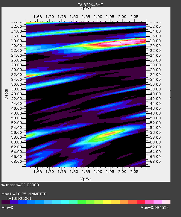
| Estimated Moho Depth: |
18.25 km |
| Estimated Crust Vp/Vs: |
1.99 |
| Assumed Crust Vp: |
5.738 km/s |
| Estimated Crust Vs: |
2.88 km/s |
| Estimated Crust Poisson's Ratio: |
0.33 |
|
| Radial Match: |
93.83308 % |
| Radial Bump: |
400 |
| Transverse Match: |
91.93269 % |
| Transverse Bump: |
400 |
| SOD ConfigId: |
13570011 |
| Insert Time: |
2019-04-29 04:33:14.375 +0000 |
| GWidth: |
2.5 |
| Max Bumps: |
400 |
| Tol: |
0.001 |
|

Signal To Noise
| Channel | StoN | STA | LTA |
| TA:B22K: :BHZ:20171112T18:29:20.974998Z | 33.169415 | 2.0035326E-5 | 6.0403016E-7 |
| TA:B22K: :BHN:20171112T18:29:20.974998Z | 5.981902 | 6.396688E-6 | 1.0693401E-6 |
| TA:B22K: :BHE:20171112T18:29:20.974998Z | 3.478532 | 2.6712803E-6 | 7.679333E-7 |
| Arrivals |
| Ps | 3.2 SECOND |
| PpPs | 9.3 SECOND |
| PsPs/PpSs | 13 SECOND |


