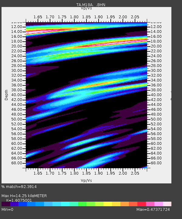
M18A Lyman, WY, USA - Earthquake Result Viewer
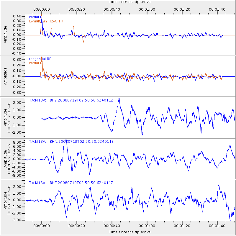
Earthquake location: Off East Coast Of Honshu, Japan
Earthquake latitude/longitude: 37.6/142.2
Earthquake time(UTC): 2008/07/19 (201) 02:39:28 GMT
Earthquake Depth: 22 km
Earthquake Magnitude: 6.2 MB, 7.0 MS, 7.0 MW, 6.9 MW
Earthquake Catalog/Contributor: WHDF/NEIC
Network: TA USArray Transportable Network (new EarthScope stations)
Station: M18A Lyman, WY, USA
Lat/Lon: 41.43 N/110.07 W
Elevation: 2103 m
Distance: 77.4 deg
Az: 47.223 deg
Baz: 309.126 deg
Ray Param: 0.05032608
Estimated Moho Depth: 14.25 km
Estimated Crust Vp/Vs: 1.61
Assumed Crust Vp: 6.155 km/s
Estimated Crust Vs: 3.829 km/s
Estimated Crust Poisson's Ratio: 0.18
Radial Match: 92.3914 %
Radial Bump: 400
Transverse Match: 82.73805 %
Transverse Bump: 400
SOD ConfigId: 2504
Insert Time: 2010-03-06 06:16:54.655 +0000
GWidth: 2.5
Max Bumps: 400
Tol: 0.001

Signal To Noise

ChannelStoNSTALTA
TA:M18A: :BHN:20080719T02:50:50.624011Z7.9967588.4595257E-71.0578694E-7
TA:M18A: :BHE:20080719T02:50:50.624011Z1.42732391.1126153E-77.795114E-8
TA:M18A: :BHZ:20080719T02:50:50.624011Z2.60467122.2770486E-78.742173E-8
Arrivals
Ps1.5 SECOND
PpPs5.9 SECOND
PsPs/PpSs7.3 SECOND