You are here: Home > Network List > TA - USArray Transportable Network (new EarthScope stations) Stations List
> Station E25K Arctic Village, AK, USA > Earthquake Result Viewer
E25K Arctic Village, AK, USA - Earthquake Result Viewer
| Earthquake location: |
Iran-Iraq Border Region |
| Earthquake latitude/longitude: |
34.9/46.0 |
| Earthquake time(UTC): |
2017/11/12 (316) 18:18:17 GMT |
| Earthquake Depth: |
19 km |
| Earthquake Magnitude: |
7.3 Mww |
| Earthquake Catalog/Contributor: |
NEIC PDE/us |
|
| Network: |
TA USArray Transportable Network (new EarthScope stations) |
| Station: |
E25K Arctic Village, AK, USA |
| Lat/Lon: |
68.12 N/145.57 W |
| Elevation: |
652 m |
|
| Distance: |
76.9 deg |
| Az: |
4.409 deg |
| Baz: |
350.295 deg |
| Ray Param: |
0.05065175 |
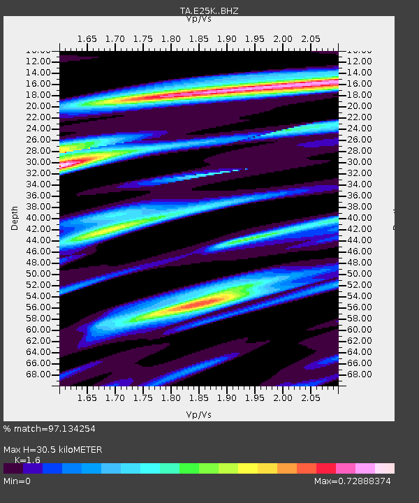
| Estimated Moho Depth: |
30.5 km |
| Estimated Crust Vp/Vs: |
1.60 |
| Assumed Crust Vp: |
6.455 km/s |
| Estimated Crust Vs: |
4.035 km/s |
| Estimated Crust Poisson's Ratio: |
0.18 |
|
| Radial Match: |
97.134254 % |
| Radial Bump: |
360 |
| Transverse Match: |
94.80073 % |
| Transverse Bump: |
400 |
| SOD ConfigId: |
13570011 |
| Insert Time: |
2019-04-29 04:33:41.452 +0000 |
| GWidth: |
2.5 |
| Max Bumps: |
400 |
| Tol: |
0.001 |
|

Signal To Noise
| Channel | StoN | STA | LTA |
| TA:E25K: :BHZ:20171112T18:29:37.000022Z | 64.279205 | 1.379111E-5 | 2.145501E-7 |
| TA:E25K: :BHN:20171112T18:29:37.000022Z | 37.48602 | 5.1498437E-6 | 1.3738038E-7 |
| TA:E25K: :BHE:20171112T18:29:37.000022Z | 15.065338 | 1.7394509E-6 | 1.15460466E-7 |
| Arrivals |
| Ps | 2.9 SECOND |
| PpPs | 12 SECOND |
| PsPs/PpSs | 15 SECOND |


