You are here: Home > Network List > TA - USArray Transportable Network (new EarthScope stations) Stations List
> Station M18A Lyman, WY, USA > Earthquake Result Viewer
M18A Lyman, WY, USA - Earthquake Result Viewer

| Earthquake location: |
Tonga Islands |
| Earthquake latitude/longitude: |
-15.1/-173.5 |
| Earthquake time(UTC): |
2008/08/19 (232) 16:30:13 GMT |
| Earthquake Depth: |
8.0 km |
| Earthquake Magnitude: |
5.6 MB, 5.9 MS, 6.1 MW, 6.0 MW |
| Earthquake Catalog/Contributor: |
WHDF/NEIC |
|
| Network: |
TA USArray Transportable Network (new EarthScope stations) |
| Station: |
M18A Lyman, WY, USA |
| Lat/Lon: |
41.43 N/110.07 W |
| Elevation: |
2103 m |
|
| Distance: |
81.1 deg |
| Az: |
42.894 deg |
| Baz: |
240.963 deg |
| Ray Param: |
0.047825642 |
| Estimated Moho Depth: |
14.5 km |
| Estimated Crust Vp/Vs: |
1.60 |
| Assumed Crust Vp: |
6.155 km/s |
| Estimated Crust Vs: |
3.847 km/s |
| Estimated Crust Poisson's Ratio: |
0.18 |
|
| Radial Match: |
86.68563 % |
| Radial Bump: |
400 |
| Transverse Match: |
65.450096 % |
| Transverse Bump: |
400 |
| SOD ConfigId: |
2504 |
| Insert Time: |
2010-03-06 06:17:05.471 +0000 |
| GWidth: |
2.5 |
| Max Bumps: |
400 |
| Tol: |
0.001 |
|
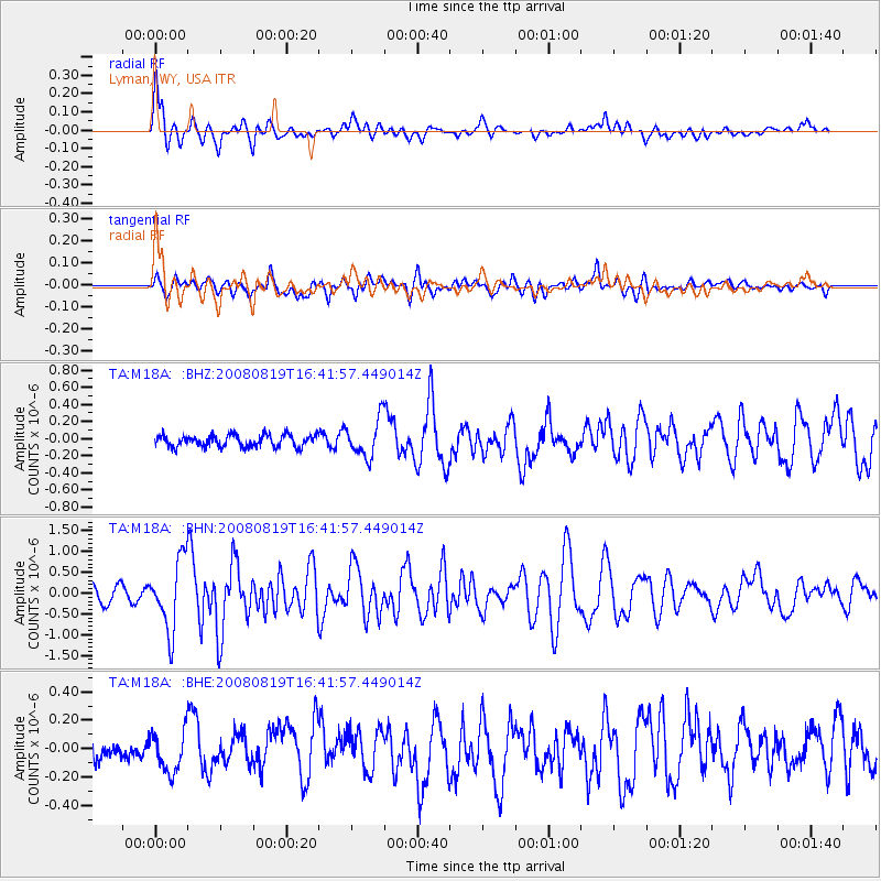
Signal To Noise
| Channel | StoN | STA | LTA |
| TA:M18A: :BHN:20080819T16:41:57.449014Z | 5.166467 | 8.404154E-7 | 1.6266732E-7 |
| TA:M18A: :BHE:20080819T16:41:57.449014Z | 1.3131672 | 1.4615364E-7 | 1.11298576E-7 |
| TA:M18A: :BHZ:20080819T16:41:57.449014Z | 3.1692169 | 2.1872796E-7 | 6.90164E-8 |
| Arrivals |
| Ps | 1.5 SECOND |
| PpPs | 6.0 SECOND |
| PsPs/PpSs | 7.4 SECOND |


