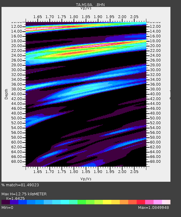
M18A Lyman, WY, USA - Earthquake Result Viewer
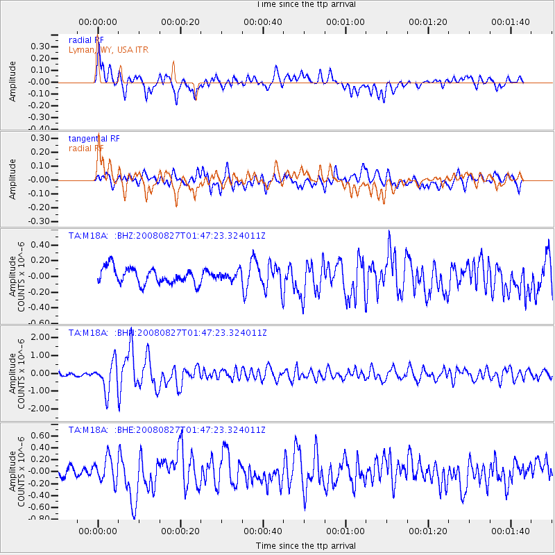
Earthquake location: Lake Baykal Region, Russia
Earthquake latitude/longitude: 51.6/104.2
Earthquake time(UTC): 2008/08/27 (240) 01:35:32 GMT
Earthquake Depth: 16 km
Earthquake Magnitude: 5.8 MB, 6.2 MS, 6.2 MW, 6.2 MW
Earthquake Catalog/Contributor: WHDF/NEIC
Network: TA USArray Transportable Network (new EarthScope stations)
Station: M18A Lyman, WY, USA
Lat/Lon: 41.43 N/110.07 W
Elevation: 2103 m
Distance: 82.7 deg
Az: 25.242 deg
Baz: 339.29 deg
Ray Param: 0.04671404
Estimated Moho Depth: 12.75 km
Estimated Crust Vp/Vs: 1.64
Assumed Crust Vp: 6.155 km/s
Estimated Crust Vs: 3.747 km/s
Estimated Crust Poisson's Ratio: 0.21
Radial Match: 81.49023 %
Radial Bump: 400
Transverse Match: 82.40839 %
Transverse Bump: 400
SOD ConfigId: 2504
Insert Time: 2010-03-06 06:17:07.630 +0000
GWidth: 2.5
Max Bumps: 400
Tol: 0.001

Signal To Noise

ChannelStoNSTALTA
TA:M18A: :BHN:20080827T01:47:23.324011Z10.1405218.6477615E-78.527926E-8
TA:M18A: :BHE:20080827T01:47:23.324011Z1.56363442.1811724E-71.3949375E-7
TA:M18A: :BHZ:20080827T01:47:23.324011Z0.54479485.4960907E-81.0088368E-7
Arrivals
Ps1.4 SECOND
PpPs5.3 SECOND
PsPs/PpSs6.7 SECOND