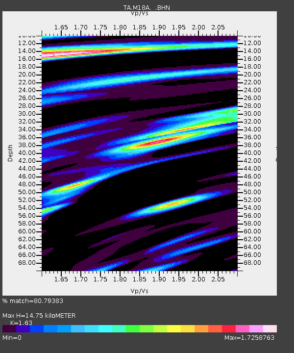
M18A Lyman, WY, USA - Earthquake Result Viewer
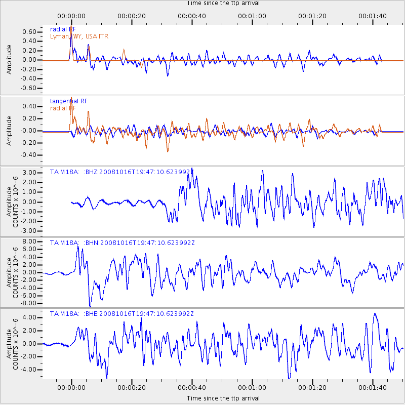
Earthquake location: Near Coast Of Chiapas, Mexico
Earthquake latitude/longitude: 14.4/-92.4
Earthquake time(UTC): 2008/10/16 (290) 19:41:25 GMT
Earthquake Depth: 24 km
Earthquake Magnitude: 6.1 MB, 6.6 MS, 6.7 MW, 6.6 MW
Earthquake Catalog/Contributor: WHDF/NEIC
Network: TA USArray Transportable Network (new EarthScope stations)
Station: M18A Lyman, WY, USA
Lat/Lon: 41.43 N/110.07 W
Elevation: 2103 m
Distance: 31.0 deg
Az: 333.634 deg
Baz: 145.096 deg
Ray Param: 0.07916875
Estimated Moho Depth: 14.75 km
Estimated Crust Vp/Vs: 1.63
Assumed Crust Vp: 6.155 km/s
Estimated Crust Vs: 3.776 km/s
Estimated Crust Poisson's Ratio: 0.20
Radial Match: 80.79383 %
Radial Bump: 400
Transverse Match: 72.251656 %
Transverse Bump: 400
SOD ConfigId: 2556
Insert Time: 2010-03-06 06:17:09.450 +0000
GWidth: 2.5
Max Bumps: 400
Tol: 0.001

Signal To Noise

ChannelStoNSTALTA
TA:M18A: :BHN:20081016T19:47:10.623992Z10.78959753.2214625E-62.9857114E-7
TA:M18A: :BHE:20081016T19:47:10.623992Z6.3716521.4426192E-62.2641213E-7
TA:M18A: :BHZ:20081016T19:47:10.623992Z4.45154331.0681657E-62.3995403E-7
Arrivals
Ps1.6 SECOND
PpPs5.8 SECOND
PsPs/PpSs7.5 SECOND