You are here: Home > Network List > TA - USArray Transportable Network (new EarthScope stations) Stations List
> Station G25K Bearman Lake, AK, USA > Earthquake Result Viewer
G25K Bearman Lake, AK, USA - Earthquake Result Viewer
| Earthquake location: |
Iran-Iraq Border Region |
| Earthquake latitude/longitude: |
34.9/46.0 |
| Earthquake time(UTC): |
2017/11/12 (316) 18:18:17 GMT |
| Earthquake Depth: |
19 km |
| Earthquake Magnitude: |
7.3 Mww |
| Earthquake Catalog/Contributor: |
NEIC PDE/us |
|
| Network: |
TA USArray Transportable Network (new EarthScope stations) |
| Station: |
G25K Bearman Lake, AK, USA |
| Lat/Lon: |
66.77 N/146.10 W |
| Elevation: |
146 m |
|
| Distance: |
78.2 deg |
| Az: |
4.856 deg |
| Baz: |
349.899 deg |
| Ray Param: |
0.04976717 |
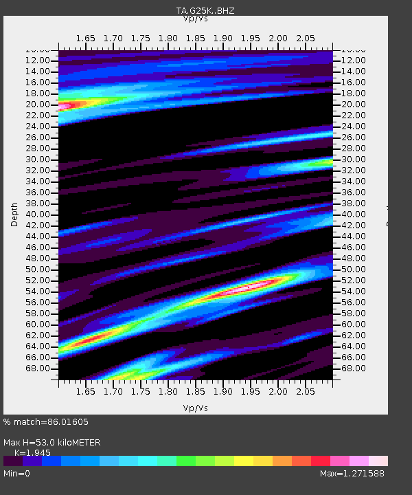
| Estimated Moho Depth: |
53.0 km |
| Estimated Crust Vp/Vs: |
1.95 |
| Assumed Crust Vp: |
6.522 km/s |
| Estimated Crust Vs: |
3.353 km/s |
| Estimated Crust Poisson's Ratio: |
0.32 |
|
| Radial Match: |
86.01605 % |
| Radial Bump: |
400 |
| Transverse Match: |
87.21352 % |
| Transverse Bump: |
362 |
| SOD ConfigId: |
13570011 |
| Insert Time: |
2019-04-29 04:34:02.638 +0000 |
| GWidth: |
2.5 |
| Max Bumps: |
400 |
| Tol: |
0.001 |
|

Signal To Noise
| Channel | StoN | STA | LTA |
| TA:G25K: :BHZ:20171112T18:29:44.274985Z | 59.924347 | 1.8033477E-5 | 3.009374E-7 |
| TA:G25K: :BHN:20171112T18:29:44.274985Z | 7.0456495 | 6.8511367E-6 | 9.723925E-7 |
| TA:G25K: :BHE:20171112T18:29:44.274985Z | 0.6029919 | 1.0868239E-6 | 1.8023857E-6 |
| Arrivals |
| Ps | 7.9 SECOND |
| PpPs | 23 SECOND |
| PsPs/PpSs | 31 SECOND |


