You are here: Home > Network List > TA - USArray Transportable Network (new EarthScope stations) Stations List
> Station G30M túh Zraii Njik, YT, CAN > Earthquake Result Viewer
G30M túh Zraii Njik, YT, CAN - Earthquake Result Viewer
| Earthquake location: |
Iran-Iraq Border Region |
| Earthquake latitude/longitude: |
34.9/46.0 |
| Earthquake time(UTC): |
2017/11/12 (316) 18:18:17 GMT |
| Earthquake Depth: |
19 km |
| Earthquake Magnitude: |
7.3 Mww |
| Earthquake Catalog/Contributor: |
NEIC PDE/us |
|
| Network: |
TA USArray Transportable Network (new EarthScope stations) |
| Station: |
G30M túh Zraii Njik, YT, CAN |
| Lat/Lon: |
66.98 N/136.22 W |
| Elevation: |
739 m |
|
| Distance: |
78.4 deg |
| Az: |
0.874 deg |
| Baz: |
358.173 deg |
| Ray Param: |
0.049637415 |
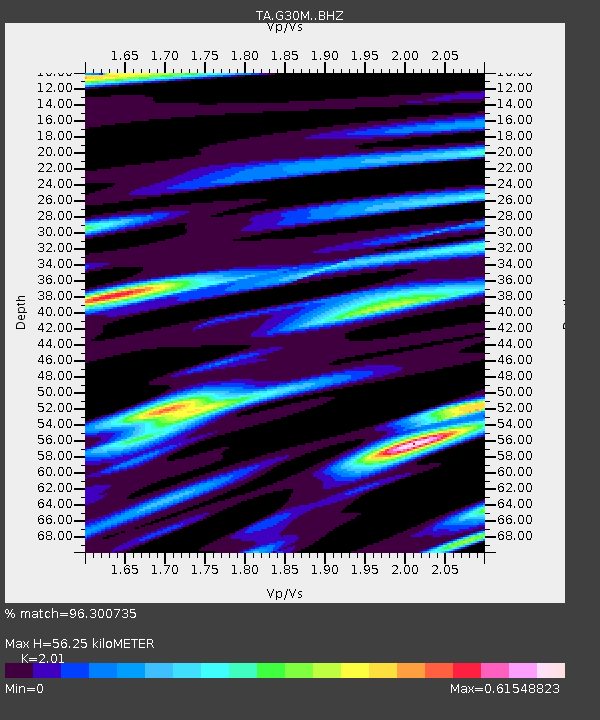
| Estimated Moho Depth: |
56.25 km |
| Estimated Crust Vp/Vs: |
2.01 |
| Assumed Crust Vp: |
6.522 km/s |
| Estimated Crust Vs: |
3.245 km/s |
| Estimated Crust Poisson's Ratio: |
0.34 |
|
| Radial Match: |
96.300735 % |
| Radial Bump: |
400 |
| Transverse Match: |
88.80834 % |
| Transverse Bump: |
400 |
| SOD ConfigId: |
13570011 |
| Insert Time: |
2019-04-29 04:34:05.023 +0000 |
| GWidth: |
2.5 |
| Max Bumps: |
400 |
| Tol: |
0.001 |
|

Signal To Noise
| Channel | StoN | STA | LTA |
| TA:G30M: :BHZ:20171112T18:29:45.324973Z | 37.709904 | 1.8022189E-5 | 4.779166E-7 |
| TA:G30M: :BHN:20171112T18:29:45.324973Z | 8.536775 | 7.0464866E-6 | 8.254273E-7 |
| TA:G30M: :BHE:20171112T18:29:45.324973Z | 10.170883 | 2.8406432E-6 | 2.792917E-7 |
| Arrivals |
| Ps | 8.9 SECOND |
| PpPs | 25 SECOND |
| PsPs/PpSs | 34 SECOND |


