You are here: Home > Network List > TA - USArray Transportable Network (new EarthScope stations) Stations List
> Station I27K Kandik River, AK, USA > Earthquake Result Viewer
I27K Kandik River, AK, USA - Earthquake Result Viewer
| Earthquake location: |
Iran-Iraq Border Region |
| Earthquake latitude/longitude: |
34.9/46.0 |
| Earthquake time(UTC): |
2017/11/12 (316) 18:18:17 GMT |
| Earthquake Depth: |
19 km |
| Earthquake Magnitude: |
7.3 Mww |
| Earthquake Catalog/Contributor: |
NEIC PDE/us |
|
| Network: |
TA USArray Transportable Network (new EarthScope stations) |
| Station: |
I27K Kandik River, AK, USA |
| Lat/Lon: |
65.60 N/141.62 W |
| Elevation: |
874 m |
|
| Distance: |
79.6 deg |
| Az: |
3.189 deg |
| Baz: |
353.679 deg |
| Ray Param: |
0.048803527 |
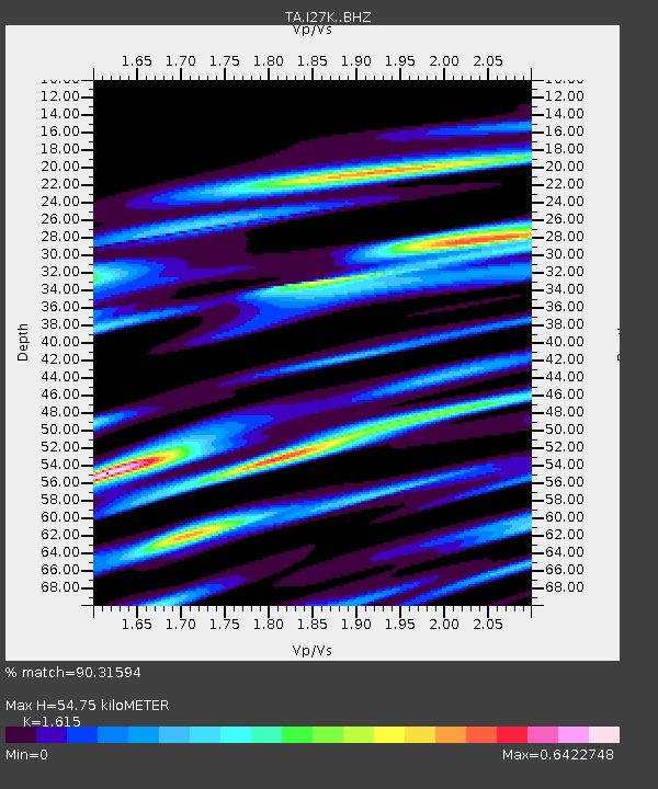
| Estimated Moho Depth: |
54.75 km |
| Estimated Crust Vp/Vs: |
1.62 |
| Assumed Crust Vp: |
6.566 km/s |
| Estimated Crust Vs: |
4.066 km/s |
| Estimated Crust Poisson's Ratio: |
0.19 |
|
| Radial Match: |
90.31594 % |
| Radial Bump: |
400 |
| Transverse Match: |
74.942024 % |
| Transverse Bump: |
400 |
| SOD ConfigId: |
13570011 |
| Insert Time: |
2019-04-29 04:34:23.483 +0000 |
| GWidth: |
2.5 |
| Max Bumps: |
400 |
| Tol: |
0.001 |
|

Signal To Noise
| Channel | StoN | STA | LTA |
| TA:I27K: :BHZ:20171112T18:29:52.000022Z | 41.85128 | 1.4259668E-5 | 3.4072238E-7 |
| TA:I27K: :BHN:20171112T18:29:52.000022Z | 11.18447 | 5.0542876E-6 | 4.5190228E-7 |
| TA:I27K: :BHE:20171112T18:29:52.000022Z | 3.3732681 | 7.887909E-7 | 2.338358E-7 |
| Arrivals |
| Ps | 5.3 SECOND |
| PpPs | 21 SECOND |
| PsPs/PpSs | 26 SECOND |


