You are here: Home > Network List > TA - USArray Transportable Network (new EarthScope stations) Stations List
> Station M18A Lyman, WY, USA > Earthquake Result Viewer
M18A Lyman, WY, USA - Earthquake Result Viewer
| Earthquake location: |
Svalbard Region |
| Earthquake latitude/longitude: |
77.1/18.6 |
| Earthquake time(UTC): |
2008/02/21 (052) 02:46:17 GMT |
| Earthquake Depth: |
10 km |
| Earthquake Magnitude: |
5.7 MB, 5.9 MS, 6.1 MW, 6.0 MW |
| Earthquake Catalog/Contributor: |
WHDF/NEIC |
|
| Network: |
TA USArray Transportable Network (new EarthScope stations) |
| Station: |
M18A Lyman, WY, USA |
| Lat/Lon: |
41.43 N/110.07 W |
| Elevation: |
2103 m |
|
| Distance: |
57.5 deg |
| Az: |
315.887 deg |
| Baz: |
12.022 deg |
| Ray Param: |
0.06342089 |
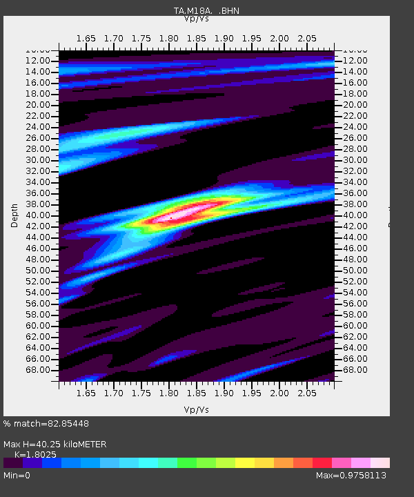
| Estimated Moho Depth: |
40.25 km |
| Estimated Crust Vp/Vs: |
1.80 |
| Assumed Crust Vp: |
6.155 km/s |
| Estimated Crust Vs: |
3.415 km/s |
| Estimated Crust Poisson's Ratio: |
0.28 |
|
| Radial Match: |
82.85448 % |
| Radial Bump: |
400 |
| Transverse Match: |
76.28884 % |
| Transverse Bump: |
400 |
| SOD ConfigId: |
2564 |
| Insert Time: |
2010-03-06 06:17:20.653 +0000 |
| GWidth: |
2.5 |
| Max Bumps: |
400 |
| Tol: |
0.001 |
|
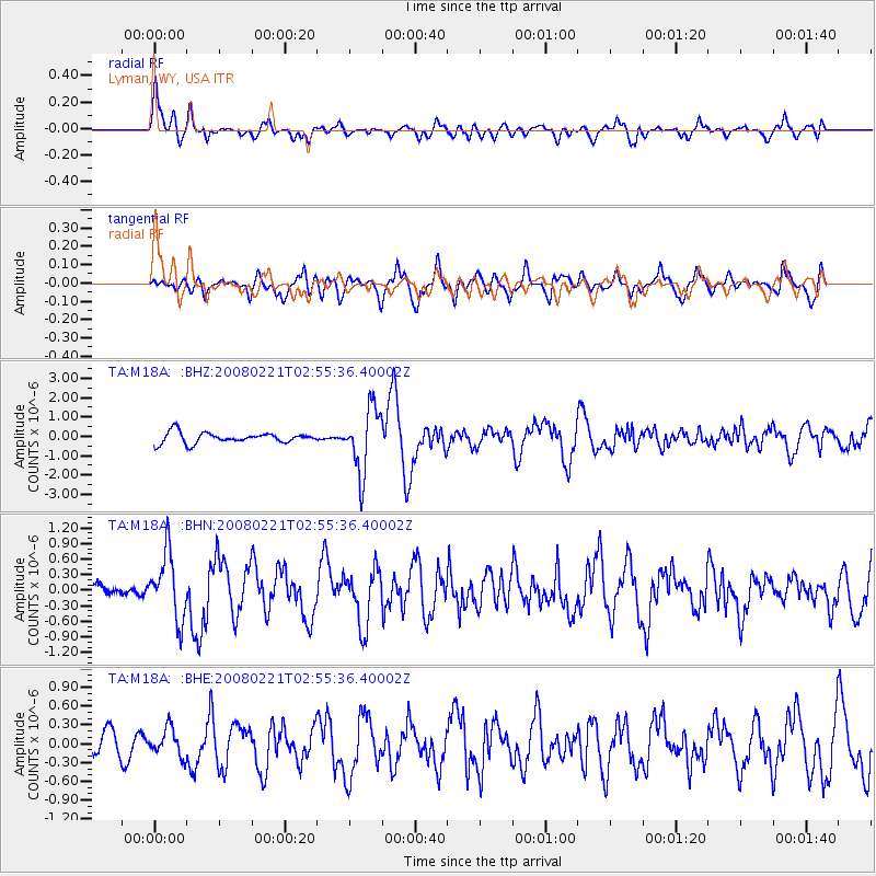
Signal To Noise
| Channel | StoN | STA | LTA |
| TA:M18A: :BHN:20080221T02:55:36.40002Z | 5.537499 | 6.294528E-7 | 1.1367096E-7 |
| TA:M18A: :BHE:20080221T02:55:36.40002Z | 0.9041134 | 2.2300411E-7 | 2.4665502E-7 |
| TA:M18A: :BHZ:20080221T02:55:36.40002Z | 6.02051 | 1.6623542E-6 | 2.7611517E-7 |
| Arrivals |
| Ps | 5.5 SECOND |
| PpPs | 18 SECOND |
| PsPs/PpSs | 23 SECOND |


