You are here: Home > Network List > TA - USArray Transportable Network (new EarthScope stations) Stations List
> Station K29M Barlow Dome, YT, CAN > Earthquake Result Viewer
K29M Barlow Dome, YT, CAN - Earthquake Result Viewer
| Earthquake location: |
Iran-Iraq Border Region |
| Earthquake latitude/longitude: |
34.9/46.0 |
| Earthquake time(UTC): |
2017/11/12 (316) 18:18:17 GMT |
| Earthquake Depth: |
19 km |
| Earthquake Magnitude: |
7.3 Mww |
| Earthquake Catalog/Contributor: |
NEIC PDE/us |
|
| Network: |
TA USArray Transportable Network (new EarthScope stations) |
| Station: |
K29M Barlow Dome, YT, CAN |
| Lat/Lon: |
63.84 N/137.52 W |
| Elevation: |
1367 m |
|
| Distance: |
81.5 deg |
| Az: |
1.557 deg |
| Baz: |
357.112 deg |
| Ray Param: |
0.047494594 |
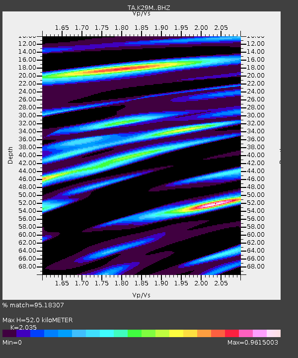
| Estimated Moho Depth: |
52.0 km |
| Estimated Crust Vp/Vs: |
2.04 |
| Assumed Crust Vp: |
6.566 km/s |
| Estimated Crust Vs: |
3.227 km/s |
| Estimated Crust Poisson's Ratio: |
0.34 |
|
| Radial Match: |
95.18307 % |
| Radial Bump: |
400 |
| Transverse Match: |
86.71802 % |
| Transverse Bump: |
400 |
| SOD ConfigId: |
13570011 |
| Insert Time: |
2019-04-29 04:34:37.400 +0000 |
| GWidth: |
2.5 |
| Max Bumps: |
400 |
| Tol: |
0.001 |
|
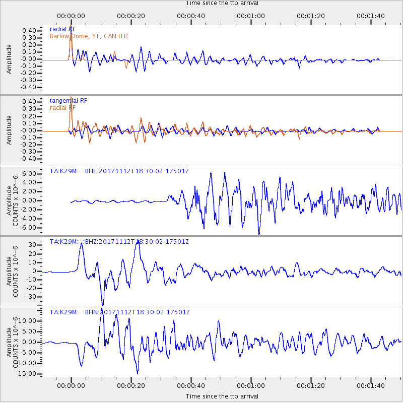
Signal To Noise
| Channel | StoN | STA | LTA |
| TA:K29M: :BHZ:20171112T18:30:02.17501Z | 43.793922 | 1.5158408E-5 | 3.461304E-7 |
| TA:K29M: :BHN:20171112T18:30:02.17501Z | 14.646327 | 4.984097E-6 | 3.4029668E-7 |
| TA:K29M: :BHE:20171112T18:30:02.17501Z | 3.6467 | 6.022719E-7 | 1.6515533E-7 |
| Arrivals |
| Ps | 8.4 SECOND |
| PpPs | 23 SECOND |
| PsPs/PpSs | 32 SECOND |


